Ludoş geodata
Ludoş (Sibiu) is a seat of a second-order administrative division; located in Romania in Europe/Bucharest (GMT+3) time zone. With population of 786 people, there are 5122 cities with bigger population in this country. Compared to other cities in Romania, 53.1% of cities are located further ↓South; 71.1% of cities are located further →East and 80.2% of cities have lower elevation than Ludoş. Note1


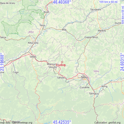
Ludoş GPS coordinates[2]
45° 55' 0.012" North, 23° 54' 0" East
| Map corner | latitude | longitude |
|---|---|---|
| Upper-left | 46.40368°, | 23.19688° |
| Center: | 45.91667°, | 23.9° |
| Lower-right: | 45.42535°, | 24.60313° |
| Map W x H: | 108.8×108.8 km | = 67.6×67.6mi |
| max Lat: | 48.23793° ⇑46.9% North |
| Ludoş: | 45.91667° |
| min Lat: | ⇓53.1% South 43.65638° |
| min Long | Ludoş | max Long |
| 20.31667° | 23.9° | 29.65403° |
| W 28.9%⇐ | ⇒71.1% E |
Elevation
Elevation of Ludoş is 395 m = 1296 ft, and this is 140.1 m = 460 ft above average elevation for this country.
| Max E: |
1278 m = 4193 ft | 19.8% |
| Ludoş | 395 m 1296 ft | |
| Avg. | 254.9 m = 836 ft | |
Min E: |
-2 m = -7 ft | 80.2% |
See also: Romania elevation on elevation.city.
Geographical zone
Ludoş is located in North temperate zone (between Tropic of Cancer and the Arctic Circle). Distance of this North polar circle is 2295.7 km =1426.5 mi to North.| Distance of | km | miles | from Ludoş |
|---|---|---|---|
| North Pole | 4901.6 | 3045.7 | to North |
| Arctic Circle | 2295.7 | 1426.5 | to North |
| Tropic Cancer | 2499.5 | 1553.1 | to South |
| Equator | 5105.5 | 3172.4 | to South |


Nearby cities:
15 places around Ludoş: (largest is in red/bold)
• Alămor
7.4 km =4.6 mi,  78°
78°
• Apoldu de Jos
6.8 km =4.2 mi,  214°
214°
• Armeni
8 km =5 mi,  46°
46°
• Cunța
13.7 km =8.5 mi,  273°
273°
• Doştat
6.8 km =4.2 mi,  325°
325°
• Drașov
12.4 km =7.7 mi,  281°
281°
• Gârbova
14 km =8.7 mi,  246°
246°
• Miercurea Sibiului
8.6 km =5.3 mi,  244°
244°
• Ocna Sibiului
12.2 km =7.6 mi,  107°
107°
• Presaca
6.6 km =4.1 mi,  352°
352°
• Păuca
11.1 km =6.9 mi,  0°
0°
• Roşia de Secaş
14.9 km =9.3 mi,  355°
355°
• Sălişte
13.4 km =8.3 mi,  184°
184°
• Tilişca
13.5 km =8.4 mi,  196°
196°
• Şpring
10.6 km =6.6 mi,  301°
301°
Sources, notices
• [Note1] Compared only with cities in Romania existing in our database
• [Src1] Map data: © OpenStreetMap contributors (CC-BY-SA)
• [Src2] Other city data from geonames.org with taken over terms of usage.
• [Src3] Geographical zone / Annual Mean Temperature by Robert A. Rohde @ Wikipedia
