Lucieni geodata
Lucieni (Dâmboviţa) is a seat of a second-order administrative division; located in Romania in Europe/Bucharest (GMT+3) time zone. With population of 6,286 people, there are 493 cities with bigger population in this country. Compared to other cities in Romania, 74.9% of cities are located further ↑North; 53.4% of cities are located further ←West and 58% of cities have lower elevation than Lucieni. Note1


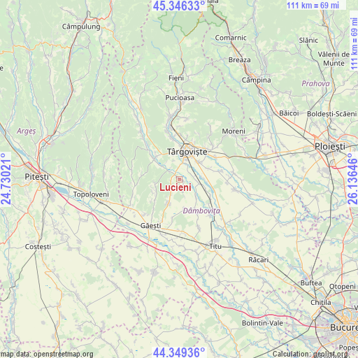
Lucieni GPS coordinates[2]
44° 51' 0" North, 25° 25' 59.988" East
| Map corner | latitude | longitude |
|---|---|---|
| Upper-left | 45.34633°, | 24.73021° |
| Center: | 44.85°, | 25.43333° |
| Lower-right: | 44.34936°, | 26.13646° |
| Map W x H: | 110.9×110.9 km | = 68.9×68.9mi |
| max Lat: | 48.23793° ⇑74.9% North |
| Lucieni: | 44.85° |
| min Lat: | ⇓25.1% South 43.65638° |
| min Long | Lucieni | max Long |
| 20.31667° | 25.43333° | 29.65403° |
| W 53.4%⇐ | ⇒46.6% E |
Elevation
Elevation of Lucieni is 253 m = 830 ft, and this is 1.9 m = 6 ft below average elevation for this country.
| Max E: |
1278 m = 4193 ft | 42% |
| Avg. | 254.9 m = 836 ft | |
| Lucieni | 253 m = 830 ft | |
Min E: |
-2 m = -7 ft | 58% |
See also: Romania elevation on elevation.city.
Geographical zone
Lucieni is located in North temperate zone (between Tropic of Cancer and the Arctic Circle). Distance of this Northern Tropic circle is 2380.9 km =1479.4 mi to South.| Distance of | km | miles | from Lucieni |
|---|---|---|---|
| North Pole | 5020.2 | 3119.4 | to North |
| Arctic Circle | 2414.3 | 1500.2 | to North |
| Tropic Cancer | 2380.9 | 1479.4 | to South |
| Equator | 4986.9 | 3098.7 | to South |


Nearby cities:
15 places around Lucieni: (largest is in red/bold)
• Boboci
6.4 km =4 mi,  207°
207°
• Bungetu
8.3 km =5.2 mi,  95°
95°
• Mislea
7.9 km =4.9 mi,  261°
261°
• Mogoșești
4.5 km =2.8 mi,  322°
322°
• Olteni
2.8 km =1.7 mi, 264°
• Perșinari
7.4 km =4.6 mi,  136°
136°
• Picior de Munte
8.2 km =5.1 mi,  204°
204°
• Raciu
3.6 km =2.2 mi,  170°
170°
• Râncăciov
7.3 km =4.5 mi,  305°
305°
• Siliștea
5.6 km =3.5 mi,  163°
163°
• Ulmi
7.6 km =4.7 mi,  43°
43°
• Ungureni
4.1 km =2.5 mi, 306°
• Viișoara
3.5 km =2.2 mi,  352°
352°
• Văcăreşti
3.9 km =2.4 mi,  90°
90°
• Șuța Seacă
2.9 km =1.8 mi,  219°
219°
Sources, notices
• [Note1] Compared only with cities in Romania existing in our database
• [Src1] Map data: © OpenStreetMap contributors (CC-BY-SA)
• [Src2] Other city data from geonames.org with taken over terms of usage.
• [Src3] Geographical zone / Annual Mean Temperature by Robert A. Rohde @ Wikipedia
