Mogoșești geodata
Mogoșești (Dâmboviţa) is a populated place; located in Romania in Europe/Bucharest (GMT+3) time zone. With population of 529 people, there are 6783 cities with bigger population in this country. Compared to other cities in Romania, 73.8% of cities are located further ↑North; 52.7% of cities are located further ←West and 61.2% of cities have lower elevation than Mogoșești. Note1


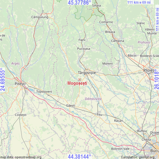
Mogoșești GPS coordinates[2]
44° 52' 54.516" North, 25° 23' 55.212" East
| Map corner | latitude | longitude |
|---|---|---|
| Upper-left | 45.37786°, | 24.69555° |
| Center: | 44.88181°, | 25.39867° |
| Lower-right: | 44.38144°, | 26.1018° |
| Map W x H: | 110.8×110.8 km | = 68.8×68.8mi |
| max Lat: | 48.23793° ⇑73.8% North |
| Mogoșești: | 44.88181° |
| min Lat: | ⇓26.2% South 43.65638° |
| min Long | Mogoșești | max Long |
| 20.31667° | 25.39867° | 29.65403° |
| W 52.7%⇐ | ⇒47.3% E |
Elevation
Elevation of Mogoșești is 270 m = 886 ft, and this is 15.1 m = 50 ft above average elevation for this country.
| Max E: |
1278 m = 4193 ft | 38.8% |
| Mogoșești | 270 m 886 ft | |
| Avg. | 254.9 m = 836 ft | |
Min E: |
-2 m = -7 ft | 61.2% |
See also: Romania elevation on elevation.city.
Geographical zone
Mogoșești is located in North temperate zone (between Tropic of Cancer and the Arctic Circle). Distance of this Northern Tropic circle is 2384.5 km =1481.7 mi to South.| Distance of | km | miles | from Mogoșești |
|---|---|---|---|
| North Pole | 5016.7 | 3117.2 | to North |
| Arctic Circle | 2410.8 | 1498 | to North |
| Tropic Cancer | 2384.5 | 1481.7 | to South |
| Equator | 4990.4 | 3100.9 | to South |


Nearby cities:
15 places around Mogoșești: (largest is in red/bold)
• Decindeni
6.6 km =4.1 mi,  300°
300°
• Dragomireşti
6.4 km =4 mi,  306°
306°
• Frasin Deal
8.6 km =5.3 mi,  224°
224°
• Lucieni
4.5 km =2.8 mi,  142°
142°
• Mislea
6.9 km =4.3 mi,  227°
227°
• Olteni
3.8 km =2.4 mi,  180°
180°
• Priseaca
4.7 km =2.9 mi,  4°
4°
• Raciu
7.9 km =4.9 mi,  154°
154°
• Râncăciov
3.3 km =2.1 mi,  283°
283°
• Târgovişte
6.7 km =4.2 mi,  43°
43°
• Ulmi
8.2 km =5.1 mi,  75°
75°
• Ungureni
1.3 km =0.8 mi,  205°
205°
• Viișoara
2.3 km =1.4 mi,  91°
91°
• Văcăreşti
7.6 km =4.7 mi,  117°
117°
• Șuța Seacă
5.9 km =3.7 mi,  171°
171°
Sources, notices
• [Note1] Compared only with cities in Romania existing in our database
• [Src1] Map data: © OpenStreetMap contributors (CC-BY-SA)
• [Src2] Other city data from geonames.org with taken over terms of usage.
• [Src3] Geographical zone / Annual Mean Temperature by Robert A. Rohde @ Wikipedia
