Perșinari geodata
Perșinari (Dâmboviţa) is a seat of a second-order administrative division; located in Romania in Europe/Bucharest (GMT+3) time zone. With population of 2,938 people, there are 1826 cities with bigger population in this country. Compared to other cities in Romania, 76.5% of cities are located further ↑North; 54.5% of cities are located further ←West and 53.5% of cities have lower elevation than Perșinari. Note1


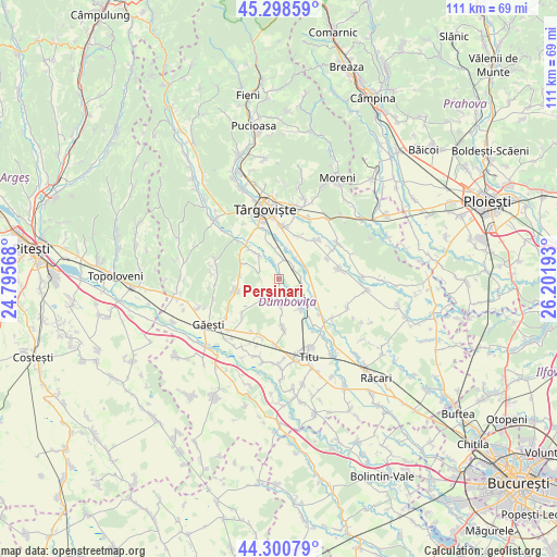
Perșinari GPS coordinates[2]
44° 48' 6.66" North, 25° 29' 55.68" East
| Map corner | latitude | longitude |
|---|---|---|
| Upper-left | 45.29859°, | 24.79568° |
| Center: | 44.80185°, | 25.4988° |
| Lower-right: | 44.30079°, | 26.20193° |
| Map W x H: | 110.9×110.9 km | = 68.9×68.9mi |
| max Lat: | 48.23793° ⇑76.5% North |
| Perșinari: | 44.80185° |
| min Lat: | ⇓23.5% South 43.65638° |
| min Long | Perșinari | max Long |
| 20.31667° | 25.4988° | 29.65403° |
| W 54.5%⇐ | ⇒45.5% E |
Elevation
Elevation of Perșinari is 231 m = 758 ft, and this is 23.9 m = 78 ft below average elevation for this country.
| Max E: |
1278 m = 4193 ft | 46.5% |
| Avg. | 254.9 m = 836 ft | |
| Perșinari | 231 m = 758 ft | |
Min E: |
-2 m = -7 ft | 53.5% |
See also: Romania elevation on elevation.city.
Geographical zone
Perșinari is located in North temperate zone (between Tropic of Cancer and the Arctic Circle). Distance of this Northern Tropic circle is 2375.6 km =1476.1 mi to South.| Distance of | km | miles | from Perșinari |
|---|---|---|---|
| North Pole | 5025.6 | 3122.8 | to North |
| Arctic Circle | 2419.7 | 1503.5 | to North |
| Tropic Cancer | 2375.6 | 1476.1 | to South |
| Equator | 4981.5 | 3095.4 | to South |


Nearby cities:
15 places around Perșinari: (largest is in red/bold)
• Boboci
8.1 km =5 mi,  267°
267°
• Brăteștii de Jos
3.5 km =2.2 mi,  52°
52°
• Bungetu
5.6 km =3.5 mi,  34°
34°
• Cazaci
4.4 km =2.7 mi,  90°
90°
• Ghinești
7.4 km =4.6 mi,  144°
144°
• Gura Şuţii
5.9 km =3.7 mi,  166°
166°
• Ilfoveni
5.7 km =3.5 mi,  60°
60°
• Lucieni
7.4 km =4.6 mi,  316°
316°
• Mircea Vodă
8.1 km =5 mi,  118°
118°
• Nucet
4.5 km =2.8 mi, 117°
• Raciu
4.9 km =3 mi,  291°
291°
• Siliștea
3.6 km =2.2 mi, 269°
• Speriețeni
5.4 km =3.4 mi,  222°
222°
• Văcăreşti
5.5 km =3.4 mi,  347°
347°
• Șuța Seacă
7.7 km =4.8 mi, 293°
Sources, notices
• [Note1] Compared only with cities in Romania existing in our database
• [Src1] Map data: © OpenStreetMap contributors (CC-BY-SA)
• [Src2] Other city data from geonames.org with taken over terms of usage.
• [Src3] Geographical zone / Annual Mean Temperature by Robert A. Rohde @ Wikipedia
