Livada geodata
Livada (Arad) is a seat of a second-order administrative division; located in Romania in Europe/Bucharest (GMT+3) time zone. With population of 2,840 people, there are 1883 cities with bigger population in this country. Compared to other cities in Romania, 60.1% of cities are located further ↓South; 98.1% of cities are located further →East and 74.8% of cities have higher elevation than Livada. Note1


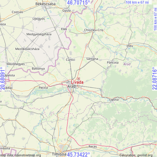
Livada GPS coordinates[2]
46° 13' 22.224" North, 21° 23' 2.508" East
| Map corner | latitude | longitude |
|---|---|---|
| Upper-left | 46.70715°, | 20.68091° |
| Center: | 46.22284°, | 21.38403° |
| Lower-right: | 45.73422°, | 22.08716° |
| Map W x H: | 108.2×108.2 km | = 67.2×67.2mi |
| max Lat: | 48.23793° ⇑39.9% North |
| Livada: | 46.22284° |
| min Lat: | ⇓60.1% South 43.65638° |
| min Long | Livada | max Long |
| 20.31667° | 21.38403° | 29.65403° |
| W 1.9%⇐ | ⇒98.1% E |
Elevation
Elevation of Livada is 111 m = 364 ft, and this is 143.9 m = 472 ft below average elevation for this country.
| Max E: |
1278 m = 4193 ft | 74.8% |
| Avg. | 254.9 m = 836 ft | |
| Livada | 111 m = 364 ft | |
Min E: |
-2 m = -7 ft | 25.2% |
See also: Romania elevation on elevation.city.
Geographical zone
Livada is located in North temperate zone (between Tropic of Cancer and the Arctic Circle). Distance of this North polar circle is 2261.7 km =1405.4 mi to North.| Distance of | km | miles | from Livada |
|---|---|---|---|
| North Pole | 4867.6 | 3024.6 | to North |
| Arctic Circle | 2261.7 | 1405.4 | to North |
| Tropic Cancer | 2533.6 | 1574.3 | to South |
| Equator | 5139.5 | 3193.5 | to South |


Nearby cities:
15 places around Livada: (largest is in red/bold)
• Aluniș
16.5 km =10.3 mi,  150°
150°
• Andrei Șaguna
7.3 km =4.5 mi,  4°
4°
• Arad
6.8 km =4.2 mi,  229°
229°
• Curtici
15.5 km =9.6 mi,  335°
335°
• Frumușeni
14.7 km =9.1 mi,  155°
155°
• Fântânele
11 km =6.8 mi,  179°
179°
• Horia
6.3 km =3.9 mi,  104°
104°
• Mândruloc
10.4 km =6.5 mi,  142°
142°
• Sâmbăteni
14.3 km =8.9 mi,  129°
129°
• Sânpaul
9.7 km =6 mi,  293°
293°
• Sântana
16.7 km =10.4 mi,  32°
32°
• Vladimirescu
6.4 km =4 mi,  168°
168°
• Zimandu Nou
6.8 km =4.2 mi,  10°
10°
• Zădăreni
16.2 km =10.1 mi, 231°
• Şofronea
8.1 km =5 mi,  307°
307°
Sources, notices
• [Note1] Compared only with cities in Romania existing in our database
• [Src1] Map data: © OpenStreetMap contributors (CC-BY-SA)
• [Src2] Other city data from geonames.org with taken over terms of usage.
• [Src3] Geographical zone / Annual Mean Temperature by Robert A. Rohde @ Wikipedia
