Lipova geodata
Lipova (Bacău) is a seat of a second-order administrative division; located in Romania in Europe/Bucharest (GMT+3) time zone. With population of 2,916 people, there are 1838 cities with bigger population in this country. Compared to other cities in Romania, 72% of cities are located further ↓South; 87.3% of cities are located further ←West and 56.7% of cities have lower elevation than Lipova. Note1


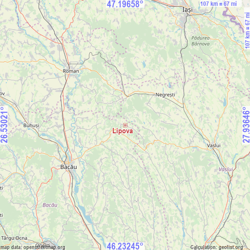
Lipova GPS coordinates[2]
46° 43' 0.012" North, 27° 13' 59.988" East
| Map corner | latitude | longitude |
|---|---|---|
| Upper-left | 47.19658°, | 26.53021° |
| Center: | 46.71667°, | 27.23333° |
| Lower-right: | 46.23245°, | 27.93646° |
| Map W x H: | 107.2×107.2 km | = 66.6×66.6mi |
| max Lat: | 48.23793° ⇑28% North |
| Lipova: | 46.71667° |
| min Lat: | ⇓72% South 43.65638° |
| min Long | Lipova | max Long |
| 20.31667° | 27.23333° | 29.65403° |
| W 87.3%⇐ | ⇒12.7% E |
Elevation
Elevation of Lipova is 246 m = 807 ft, and this is 8.9 m = 29 ft below average elevation for this country.
| Max E: |
1278 m = 4193 ft | 43.3% |
| Avg. | 254.9 m = 836 ft | |
| Lipova | 246 m = 807 ft | |
Min E: |
-2 m = -7 ft | 56.7% |
See also: Romania elevation on elevation.city.
Geographical zone
Lipova is located in North temperate zone (between Tropic of Cancer and the Arctic Circle). Distance of this North polar circle is 2206.8 km =1371.2 mi to North.| Distance of | km | miles | from Lipova |
|---|---|---|---|
| North Pole | 4812.7 | 2990.5 | to North |
| Arctic Circle | 2206.8 | 1371.2 | to North |
| Tropic Cancer | 2588.5 | 1608.4 | to South |
| Equator | 5194.4 | 3227.6 | to South |


Nearby cities:
15 places around Lipova: (largest is in red/bold)
• Armășoaia
11.9 km =7.4 mi,  105°
105°
• Ciuturești
8.8 km =5.5 mi,  251°
251°
• Cuci
12.7 km =7.9 mi,  347°
347°
• Doagele
9.1 km =5.7 mi,  124°
124°
• Fundu Tutovei
4.1 km =2.5 mi,  236°
236°
• Gârceni
6.7 km =4.2 mi,  34°
34°
• Mâlosu
5 km =3.1 mi,  298°
298°
• Odobești
7.8 km =4.8 mi,  234°
234°
• Plopana
3.9 km =2.4 mi,  198°
198°
• Pungeşti
7.8 km =4.8 mi,  103°
103°
• Roşiori
11.4 km =7.1 mi,  270°
270°
• Satu Nou
5.9 km =3.7 mi, 121°
• Secuieni
12.6 km =7.8 mi, 233°
• Solca
7.6 km =4.7 mi,  309°
309°
• Tisa-Silvestri
10 km =6.2 mi, 225°
Sources, notices
• [Note1] Compared only with cities in Romania existing in our database
• [Src1] Map data: © OpenStreetMap contributors (CC-BY-SA)
• [Src2] Other city data from geonames.org with taken over terms of usage.
• [Src3] Geographical zone / Annual Mean Temperature by Robert A. Rohde @ Wikipedia
