Leleasca geodata
Leleasca (Olt) is a seat of a second-order administrative division; located in Romania in Europe/Bucharest (GMT+3) time zone. With population of 1,819 people, there are 2808 cities with bigger population in this country. Compared to other cities in Romania, 77.4% of cities are located further ↑North; 61.3% of cities are located further →East and 74.1% of cities have lower elevation than Leleasca. Note1


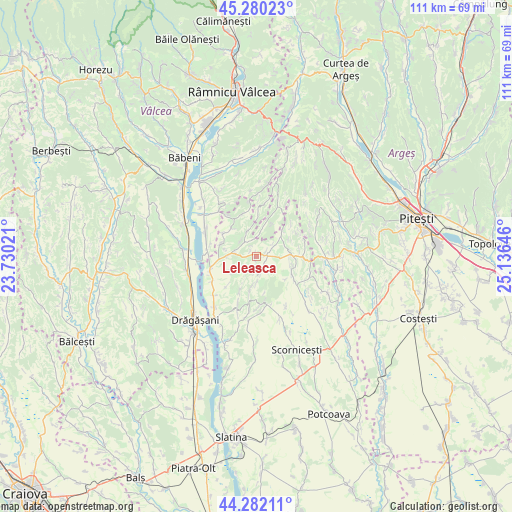
Leleasca GPS coordinates[2]
44° 46' 59.988" North, 24° 25' 59.988" East
| Map corner | latitude | longitude |
|---|---|---|
| Upper-left | 45.28023°, | 23.73021° |
| Center: | 44.78333°, | 24.43333° |
| Lower-right: | 44.28211°, | 25.13646° |
| Map W x H: | 111×111 km | = 69×69mi |
| max Lat: | 48.23793° ⇑77.4% North |
| Leleasca: | 44.78333° |
| min Lat: | ⇓22.6% South 43.65638° |
| min Long | Leleasca | max Long |
| 20.31667° | 24.43333° | 29.65403° |
| W 38.7%⇐ | ⇒61.3% E |
Elevation
Elevation of Leleasca is 347 m = 1138 ft, and this is 92.1 m = 302 ft above average elevation for this country.
| Max E: |
1278 m = 4193 ft | 25.9% |
| Leleasca | 347 m 1138 ft | |
| Avg. | 254.9 m = 836 ft | |
Min E: |
-2 m = -7 ft | 74.1% |
See also: Romania elevation on elevation.city.
Geographical zone
Leleasca is located in North temperate zone (between Tropic of Cancer and the Arctic Circle). Distance of this Northern Tropic circle is 2373.5 km =1474.8 mi to South.| Distance of | km | miles | from Leleasca |
|---|---|---|---|
| North Pole | 5027.6 | 3124 | to North |
| Arctic Circle | 2421.7 | 1504.8 | to North |
| Tropic Cancer | 2373.5 | 1474.8 | to South |
| Equator | 4979.4 | 3094.1 | to South |


Nearby cities:
15 places around Leleasca: (largest is in red/bold)
• Albești
10.7 km =6.6 mi,  168°
168°
• Alunișu
11.8 km =7.3 mi,  128°
128°
• Ceretu
11.6 km =7.2 mi,  8°
8°
• Ciomăgeşti
5.7 km =3.5 mi, 13°
• Cornățelu
11.4 km =7.1 mi, 165°
• Dejești
8 km =5 mi,  311°
311°
• Dienci
6.5 km =4 mi,  242°
242°
• Dobroteasa
3.9 km =2.4 mi,  270°
270°
• Drăgoeşti
11.2 km =7 mi,  289°
289°
• Făgeţelu
7.9 km =4.9 mi,  90°
90°
• Geamăna
11.2 km =7 mi,  283°
283°
• Sâmbureşti
2.3 km =1.4 mi,  324°
324°
• Topana
7.5 km =4.7 mi,  60°
60°
• Vitomireşti
9.6 km =6 mi,  344°
344°
• Vultureşti
10.8 km =6.7 mi, 238°
Sources, notices
• [Note1] Compared only with cities in Romania existing in our database
• [Src1] Map data: © OpenStreetMap contributors (CC-BY-SA)
• [Src2] Other city data from geonames.org with taken over terms of usage.
• [Src3] Geographical zone / Annual Mean Temperature by Robert A. Rohde @ Wikipedia
