Alunișu geodata
Alunișu (Olt) is a seat of a second-order administrative division; located in Romania in Europe/Bucharest (GMT+3) time zone. With population of 409 people, there are 7036 cities with bigger population in this country. Compared to other cities in Romania, 79.7% of cities are located further ↑North; 59.6% of cities are located further →East and 69% of cities have lower elevation than Alunișu. Note1


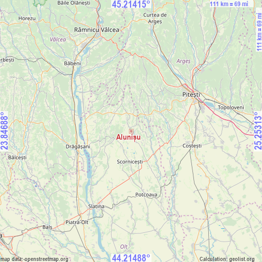
Alunișu GPS coordinates[2]
44° 43' 0.012" North, 24° 33' 0" East
| Map corner | latitude | longitude |
|---|---|---|
| Upper-left | 45.21415°, | 23.84688° |
| Center: | 44.71667°, | 24.55° |
| Lower-right: | 44.21488°, | 25.25313° |
| Map W x H: | 111.1×111.1 km | = 69×69mi |
| max Lat: | 48.23793° ⇑79.7% North |
| Alunișu: | 44.71667° |
| min Lat: | ⇓20.3% South 43.65638° |
| min Long | Alunișu | max Long |
| 20.31667° | 24.55° | 29.65403° |
| W 40.4%⇐ | ⇒59.6% E |
Elevation
Elevation of Alunișu is 312 m = 1024 ft, and this is 57.1 m = 187 ft above average elevation for this country.
| Max E: |
1278 m = 4193 ft | 31% |
| Alunișu | 312 m 1024 ft | |
| Avg. | 254.9 m = 836 ft | |
Min E: |
-2 m = -7 ft | 69% |
See also: Romania elevation on elevation.city.
Geographical zone
Alunișu is located in North temperate zone (between Tropic of Cancer and the Arctic Circle). Distance of this Northern Tropic circle is 2366.1 km =1470.2 mi to South.| Distance of | km | miles | from Alunișu |
|---|---|---|---|
| North Pole | 5035 | 3128.6 | to North |
| Arctic Circle | 2429.1 | 1509.4 | to North |
| Tropic Cancer | 2366.1 | 1470.2 | to South |
| Equator | 4972 | 3089.5 | to South |


Nearby cities:
15 places around Alunișu: (largest is in red/bold)
• Albești
7.7 km =4.8 mi,  246°
246°
• Bărăștii de Vede
8.6 km =5.3 mi,  90°
90°
• Coloneşti
11.8 km =7.3 mi,  128°
128°
• Constantinești
14.1 km =8.8 mi,  195°
195°
• Cornățelu
7.2 km =4.5 mi,  240°
240°
• Făgeţelu
7.5 km =4.7 mi,  349°
349°
• Izvoru de Sus
13.6 km =8.5 mi,  35°
35°
• Leleasca
11.8 km =7.3 mi,  308°
308°
• Poboru
6.8 km =4.2 mi,  215°
215°
• Profa
3.6 km =2.2 mi, 38°
• Păduroiu din Vale
13.9 km =8.6 mi,  57°
57°
• Sâmbureşti
14 km =8.7 mi, 311°
• Topana
11.4 km =7.1 mi, 346°
• Tătuleşti
11.4 km =7.1 mi,  144°
144°
• Vedea
9.1 km =5.7 mi, 35°
Sources, notices
• [Note1] Compared only with cities in Romania existing in our database
• [Src1] Map data: © OpenStreetMap contributors (CC-BY-SA)
• [Src2] Other city data from geonames.org with taken over terms of usage.
• [Src3] Geographical zone / Annual Mean Temperature by Robert A. Rohde @ Wikipedia
