Cornățelu geodata
Cornățelu (Olt) is a populated place; located in Romania in Europe/Bucharest (GMT+3) time zone. With population of 607 people, there are 6156 cities with bigger population in this country. Compared to other cities in Romania, 80.4% of cities are located further ↑North; 60.6% of cities are located further →East and 65.2% of cities have lower elevation than Cornățelu. Note1


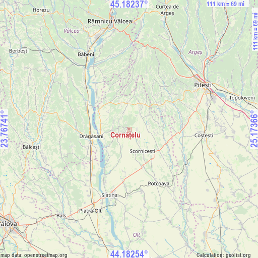
Cornățelu GPS coordinates[2]
44° 41' 4.596" North, 24° 28' 13.908" East
| Map corner | latitude | longitude |
|---|---|---|
| Upper-left | 45.18237°, | 23.76741° |
| Center: | 44.68461°, | 24.47053° |
| Lower-right: | 44.18254°, | 25.17366° |
| Map W x H: | 111.2×111.2 km | = 69.1×69.1mi |
| max Lat: | 48.23793° ⇑80.4% North |
| Cornățelu: | 44.68461° |
| min Lat: | ⇓19.6% South 43.65638° |
| min Long | Cornățelu | max Long |
| 20.31667° | 24.47053° | 29.65403° |
| W 39.4%⇐ | ⇒60.6% E |
Elevation
Elevation of Cornățelu is 291 m = 955 ft, and this is 36.1 m = 118 ft above average elevation for this country.
| Max E: |
1278 m = 4193 ft | 34.8% |
| Cornățelu | 291 m 955 ft | |
| Avg. | 254.9 m = 836 ft | |
Min E: |
-2 m = -7 ft | 65.2% |
See also: Romania elevation on elevation.city.
Geographical zone
Cornățelu is located in North temperate zone (between Tropic of Cancer and the Arctic Circle). Distance of this Northern Tropic circle is 2362.5 km =1468 mi to South.| Distance of | km | miles | from Cornățelu |
|---|---|---|---|
| North Pole | 5038.6 | 3130.8 | to North |
| Arctic Circle | 2432.7 | 1511.6 | to North |
| Tropic Cancer | 2362.5 | 1468 | to South |
| Equator | 4968.5 | 3087.3 | to South |


Nearby cities:
15 places around Cornățelu: (largest is in red/bold)
• Albești
0.9 km =0.6 mi,  303°
303°
• Alunișu
7.2 km =4.5 mi,  60°
60°
• Constantinești
10.3 km =6.4 mi,  166°
166°
• Cungrea
7.2 km =4.5 mi,  253°
253°
• Dienci
11.8 km =7.3 mi,  312°
312°
• Dobroteasa
13 km =8.1 mi,  327°
327°
• Dumitrești
12.2 km =7.6 mi,  269°
269°
• Făgeţelu
12 km =7.5 mi,  24°
24°
• Leleasca
11.4 km =7.1 mi,  345°
345°
• Oporelu
10.3 km =6.4 mi,  204°
204°
• Poboru
3.1 km =1.9 mi,  130°
130°
• Poganu
12.3 km =7.6 mi,  257°
257°
• Profa
10.7 km =6.6 mi,  53°
53°
• Valea lui Alb
12.6 km =7.8 mi,  281°
281°
• Verguleasa
12.8 km =8 mi, 252°
Sources, notices
• [Note1] Compared only with cities in Romania existing in our database
• [Src1] Map data: © OpenStreetMap contributors (CC-BY-SA)
• [Src2] Other city data from geonames.org with taken over terms of usage.
• [Src3] Geographical zone / Annual Mean Temperature by Robert A. Rohde @ Wikipedia
