Ștefănești geodata
Ștefănești (Călăraşi) is a populated place; located in Romania in Europe/Bucharest (GMT+3) time zone. With population of 637 people, there are 5964 cities with bigger population in this country. Compared to other cities in Romania, 85% of cities are located further ↑North; 77.5% of cities are located further ←West and 90.2% of cities have higher elevation than Ștefănești. Note1


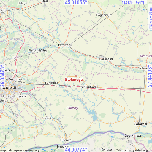
Ștefănești GPS coordinates[2]
44° 30' 40.68" North, 26° 44' 16.44" East
| Map corner | latitude | longitude |
|---|---|---|
| Upper-left | 45.01055°, | 26.03478° |
| Center: | 44.5113°, | 26.7379° |
| Lower-right: | 44.00774°, | 27.44103° |
| Map W x H: | 111.5×111.5 km | = 69.3×69.3mi |
| max Lat: | 48.23793° ⇑85% North |
| Ștefănești: | 44.5113° |
| min Lat: | ⇓15% South 43.65638° |
| min Long | Ștefănești | max Long |
| 20.31667° | 26.7379° | 29.65403° |
| W 77.5%⇐ | ⇒22.5% E |
Elevation
Elevation of Ștefănești is 57 m = 187 ft, and this is 197.9 m = 649 ft below average elevation for this country.
| Max E: |
1278 m = 4193 ft | 90.2% |
| Avg. | 254.9 m = 836 ft | |
| Ștefănești | 57 m = 187 ft | |
Min E: |
-2 m = -7 ft | 9.8% |
See also: Romania elevation on elevation.city.
Geographical zone
Ștefănești is located in North temperate zone (between Tropic of Cancer and the Arctic Circle). Distance of this Northern Tropic circle is 2343.3 km =1456.1 mi to South.| Distance of | km | miles | from Ștefănești |
|---|---|---|---|
| North Pole | 5057.9 | 3142.8 | to North |
| Arctic Circle | 2452 | 1523.6 | to North |
| Tropic Cancer | 2343.3 | 1456.1 | to South |
| Equator | 4949.2 | 3075.3 | to South |


Nearby cities:
15 places around Ștefănești: (largest is in red/bold)
• Arțari
8.1 km =5 mi,  319°
319°
• Axintele
10.5 km =6.5 mi,  20°
20°
• Buzoeni
12.3 km =7.6 mi,  151°
151°
• Condeești
13.4 km =8.3 mi,  344°
344°
• Florica
8.2 km =5.1 mi,  255°
255°
• Horia
5.9 km =3.7 mi,  60°
60°
• Ileana
5.7 km =3.5 mi,  276°
276°
• Lehliu
8 km =5 mi,  128°
128°
• Lehliu-Gară
12.4 km =7.7 mi, 134°
• Nicolae Bălcescu
7.2 km =4.5 mi,  161°
161°
• Sălcioara
11.8 km =7.3 mi,  78°
78°
• Săndulița
13.3 km =8.3 mi,  218°
218°
• Săpunari
7.9 km =4.9 mi,  97°
97°
• Săruleşti
12.6 km =7.8 mi,  213°
213°
• Sărulești-Gară
9.8 km =6.1 mi, 220°
Sources, notices
• [Note1] Compared only with cities in Romania existing in our database
• [Src1] Map data: © OpenStreetMap contributors (CC-BY-SA)
• [Src2] Other city data from geonames.org with taken over terms of usage.
• [Src3] Geographical zone / Annual Mean Temperature by Robert A. Rohde @ Wikipedia
