Lăpuş geodata
Lăpuş (Maramureş) is a seat of a second-order administrative division; located in Romania in Europe/Bucharest (GMT+3) time zone. With population of 3,769 people, there are 1283 cities with bigger population in this country. Compared to other cities in Romania, 90.9% of cities are located further ↓South; 69.1% of cities are located further →East and 79.7% of cities have lower elevation than Lăpuş. Note1


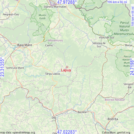
Lăpuş GPS coordinates[2]
47° 30' 0" North, 24° 1' 0.012" East
| Map corner | latitude | longitude |
|---|---|---|
| Upper-left | 47.97288°, | 23.31355° |
| Center: | 47.5°, | 24.01667° |
| Lower-right: | 47.02283°, | 24.7198° |
| Map W x H: | 105.6×105.6 km | = 65.6×65.6mi |
| max Lat: | 48.23793° ⇑9.1% North |
| Lăpuş: | 47.5° |
| min Lat: | ⇓90.9% South 43.65638° |
| min Long | Lăpuş | max Long |
| 20.31667° | 24.01667° | 29.65403° |
| W 30.9%⇐ | ⇒69.1% E |
Elevation
Elevation of Lăpuş is 390 m = 1280 ft, and this is 135.1 m = 443 ft above average elevation for this country.
| Max E: |
1278 m = 4193 ft | 20.3% |
| Lăpuş | 390 m 1280 ft | |
| Avg. | 254.9 m = 836 ft | |
Min E: |
-2 m = -7 ft | 79.7% |
See also: Romania elevation on elevation.city.
Geographical zone
Lăpuş is located in North temperate zone (between Tropic of Cancer and the Arctic Circle). Distance of this North polar circle is 2119.7 km =1317.1 mi to North.| Distance of | km | miles | from Lăpuş |
|---|---|---|---|
| North Pole | 4725.6 | 2936.4 | to North |
| Arctic Circle | 2119.7 | 1317.1 | to North |
| Tropic Cancer | 2675.6 | 1662.5 | to South |
| Equator | 5281.5 | 3281.8 | to South |


Nearby cities:
15 places around Lăpuş: (largest is in red/bold)
• Agrieș
14.2 km =8.8 mi,  141°
141°
• Borcut
13.4 km =8.3 mi,  261°
261°
• Breaza
16.9 km =10.5 mi,  168°
168°
• Băiuţ
13 km =8.1 mi,  354°
354°
• Costeni
8.7 km =5.4 mi,  298°
298°
• Cupşeni
8.4 km =5.2 mi,  311°
311°
• Dămăcușeni
9.4 km =5.8 mi,  239°
239°
• Groșii Țibleșului
3.7 km =2.3 mi,  107°
107°
• Larga
8.5 km =5.3 mi,  128°
128°
• Libotin
3.7 km =2.3 mi,  279°
279°
• Rogoz
7.3 km =4.5 mi, 240°
• Suciu de Jos
6.5 km =4 mi,  203°
203°
• Suciu de Sus
7.5 km =4.7 mi, 170°
• Târgu Lăpuş
12.5 km =7.8 mi,  245°
245°
• Ungureni
7.1 km =4.4 mi,  316°
316°
Sources, notices
• [Note1] Compared only with cities in Romania existing in our database
• [Src1] Map data: © OpenStreetMap contributors (CC-BY-SA)
• [Src2] Other city data from geonames.org with taken over terms of usage.
• [Src3] Geographical zone / Annual Mean Temperature by Robert A. Rohde @ Wikipedia
