Agrieș geodata
Agrieș (Bistriţa-Năsăud) is a populated place; located in Romania in Europe/Bucharest (GMT+3) time zone. With population of 1,024 people, there are 4208 cities with bigger population in this country. Compared to other cities in Romania, 88.9% of cities are located further ↓South; 67.1% of cities are located further →East and 79.6% of cities have lower elevation than Agrieș. Note1


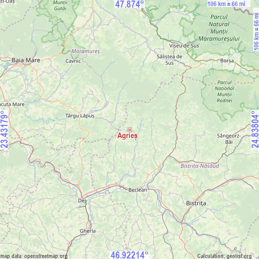
Agrieș GPS coordinates[2]
47° 24' 0.792" North, 24° 8' 5.676" East
| Map corner | latitude | longitude |
|---|---|---|
| Upper-left | 47.874°, | 23.43179° |
| Center: | 47.40022°, | 24.13491° |
| Lower-right: | 46.92214°, | 24.83804° |
| Map W x H: | 105.8×105.8 km | = 65.7×65.7mi |
| max Lat: | 48.23793° ⇑11.1% North |
| Agrieș: | 47.40022° |
| min Lat: | ⇓88.9% South 43.65638° |
| min Long | Agrieș | max Long |
| 20.31667° | 24.13491° | 29.65403° |
| W 32.9%⇐ | ⇒67.1% E |
Elevation
Elevation of Agrieș is 389 m = 1276 ft, and this is 134.1 m = 440 ft above average elevation for this country.
| Max E: |
1278 m = 4193 ft | 20.4% |
| Agrieș | 389 m 1276 ft | |
| Avg. | 254.9 m = 836 ft | |
Min E: |
-2 m = -7 ft | 79.6% |
See also: Romania elevation on elevation.city.
Geographical zone
Agrieș is located in North temperate zone (between Tropic of Cancer and the Arctic Circle). Distance of this North polar circle is 2130.8 km =1324 mi to North.| Distance of | km | miles | from Agrieș |
|---|---|---|---|
| North Pole | 4736.7 | 2943.2 | to North |
| Arctic Circle | 2130.8 | 1324 | to North |
| Tropic Cancer | 2664.5 | 1655.6 | to South |
| Equator | 5270.4 | 3274.9 | to South |


Nearby cities:
15 places around Agrieș: (largest is in red/bold)
• Borleasa
6.8 km =4.2 mi,  152°
152°
• Breaza
7.7 km =4.8 mi,  225°
225°
• Ciceu-Poieni
11.7 km =7.3 mi,  197°
197°
• Dobricel
11.6 km =7.2 mi,  187°
187°
• Groșii Țibleșului
11.3 km =7 mi,  331°
331°
• Larga
6.2 km =3.9 mi,  338°
338°
• Perișor
11.8 km =7.3 mi,  144°
144°
• Poienile Zagrei
9.3 km =5.8 mi,  98°
98°
• Răpănaşu
4.1 km =2.5 mi,  117°
117°
• Spermezeu
11.2 km =7 mi,  174°
174°
• Suciu de Jos
12.5 km =7.8 mi,  293°
293°
• Suciu de Sus
8.5 km =5.3 mi,  295°
295°
• Suplai
10.2 km =6.3 mi,  66°
66°
• Târlişua
4.1 km =2.5 mi, 117°
• Zagra
13.4 km =8.3 mi, 123°
Sources, notices
• [Note1] Compared only with cities in Romania existing in our database
• [Src1] Map data: © OpenStreetMap contributors (CC-BY-SA)
• [Src2] Other city data from geonames.org with taken over terms of usage.
• [Src3] Geographical zone / Annual Mean Temperature by Robert A. Rohde @ Wikipedia
