Lăpoș geodata
Lăpoș (Bacău) is a populated place; located in Romania in Europe/Bucharest (GMT+3) time zone. With population of 1,455 people, there are 3251 cities with bigger population in this country. Compared to other cities in Romania, 64.4% of cities are located further ↓South; 71.9% of cities are located further ←West and 84.7% of cities have lower elevation than Lăpoș. Note1


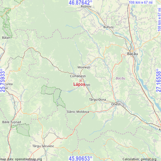
Lăpoș GPS coordinates[2]
46° 23' 37.068" North, 26° 27' 44.82" East
| Map corner | latitude | longitude |
|---|---|---|
| Upper-left | 46.87642°, | 25.75933° |
| Center: | 46.39363°, | 26.46245° |
| Lower-right: | 45.90653°, | 27.16558° |
| Map W x H: | 107.8×107.8 km | = 67×67mi |
| max Lat: | 48.23793° ⇑35.6% North |
| Lăpoș: | 46.39363° |
| min Lat: | ⇓64.4% South 43.65638° |
| min Long | Lăpoș | max Long |
| 20.31667° | 26.46245° | 29.65403° |
| W 71.9%⇐ | ⇒28.1% E |
Elevation
Elevation of Lăpoș is 443 m = 1453 ft, and this is 188.1 m = 617 ft above average elevation for this country.
| Max E: |
1278 m = 4193 ft | 15.3% |
| Lăpoș | 443 m 1453 ft | |
| Avg. | 254.9 m = 836 ft | |
Min E: |
-2 m = -7 ft | 84.7% |
See also: Romania elevation on elevation.city.
Geographical zone
Lăpoș is located in North temperate zone (between Tropic of Cancer and the Arctic Circle). Distance of this North polar circle is 2242.7 km =1393.5 mi to North.| Distance of | km | miles | from Lăpoș |
|---|---|---|---|
| North Pole | 4848.6 | 3012.8 | to North |
| Arctic Circle | 2242.7 | 1393.5 | to North |
| Tropic Cancer | 2552.6 | 1586.1 | to South |
| Equator | 5158.5 | 3205.3 | to South |


Nearby cities:
15 places around Lăpoș: (largest is in red/bold)
• Asău
6.5 km =4 mi,  312°
312°
• Comăneşti
3.7 km =2.3 mi,  327°
327°
• Dofteana
9.5 km =5.9 mi,  154°
154°
• Dărmăneşti
3.4 km =2.1 mi, 151°
• Hăghiac
10 km =6.2 mi, 154°
• Larga
7.2 km =4.5 mi,  131°
131°
• Lunca Asău
6 km =3.7 mi,  319°
319°
• Moineşti
9.3 km =5.8 mi,  12°
12°
• Plopu
3.1 km =1.9 mi,  92°
92°
• Podei
2.3 km =1.4 mi, 319°
• Poduri
9.8 km =6.1 mi,  33°
33°
• Straja
9.2 km =5.7 mi,  303°
303°
• Valea Șoșii
10.1 km =6.3 mi,  41°
41°
• Vermești
3.3 km =2.1 mi,  19°
19°
• Ștefan Vodă
9.4 km =5.8 mi,  155°
155°
Sources, notices
• [Note1] Compared only with cities in Romania existing in our database
• [Src1] Map data: © OpenStreetMap contributors (CC-BY-SA)
• [Src2] Other city data from geonames.org with taken over terms of usage.
• [Src3] Geographical zone / Annual Mean Temperature by Robert A. Rohde @ Wikipedia
