Izvorani geodata
Izvorani (Arges) is a populated place; located in Romania in Europe/Bucharest (GMT+3) time zone. With population of 791 people, there are 5095 cities with bigger population in this country. Compared to other cities in Romania, 74% of cities are located further ↑North; 53.5% of cities are located further →East and 68.6% of cities have lower elevation than Izvorani. Note1


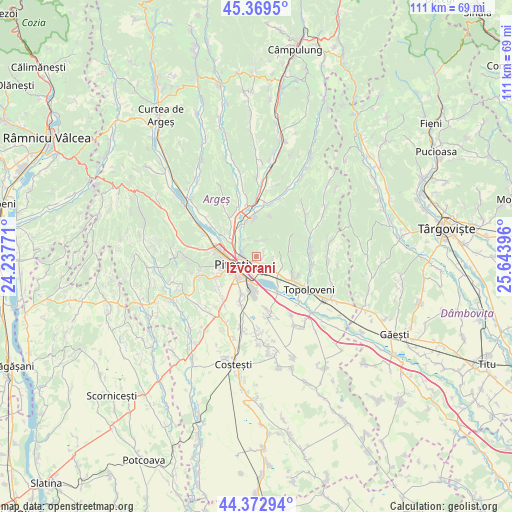
Izvorani GPS coordinates[2]
44° 52' 24.168" North, 24° 56' 26.988" East
| Map corner | latitude | longitude |
|---|---|---|
| Upper-left | 45.3695°, | 24.23771° |
| Center: | 44.87338°, | 24.94083° |
| Lower-right: | 44.37294°, | 25.64396° |
| Map W x H: | 110.8×110.8 km | = 68.8×68.8mi |
| max Lat: | 48.23793° ⇑74% North |
| Izvorani: | 44.87338° |
| min Lat: | ⇓26% South 43.65638° |
| min Long | Izvorani | max Long |
| 20.31667° | 24.94083° | 29.65403° |
| W 46.5%⇐ | ⇒53.5% E |
Elevation
Elevation of Izvorani is 310 m = 1017 ft, and this is 55.1 m = 181 ft above average elevation for this country.
| Max E: |
1278 m = 4193 ft | 31.4% |
| Izvorani | 310 m 1017 ft | |
| Avg. | 254.9 m = 836 ft | |
Min E: |
-2 m = -7 ft | 68.6% |
See also: Romania elevation on elevation.city.
Geographical zone
Izvorani is located in North temperate zone (between Tropic of Cancer and the Arctic Circle). Distance of this Northern Tropic circle is 2383.5 km =1481 mi to South.| Distance of | km | miles | from Izvorani |
|---|---|---|---|
| North Pole | 5017.6 | 3117.8 | to North |
| Arctic Circle | 2411.7 | 1498.6 | to North |
| Tropic Cancer | 2383.5 | 1481 | to South |
| Equator | 4989.5 | 3100.3 | to South |


Nearby cities:
15 places around Izvorani: (largest is in red/bold)
• Ciocănești
3.3 km =2.1 mi,  136°
136°
• Cârstieni
7.1 km =4.4 mi,  81°
81°
• Enculești
3.5 km =2.2 mi,  9°
9°
• Făgetu
4.3 km =2.7 mi,  327°
327°
• Geamăna
7.1 km =4.4 mi,  213°
213°
• Golești
4.2 km =2.6 mi,  152°
152°
• Mărăcineni
5.4 km =3.4 mi,  303°
303°
• Piteşti
6.4 km =4 mi,  246°
246°
• Radu Negru
5.6 km =3.5 mi,  102°
102°
• Udeni-Zăvoi
6.7 km =4.2 mi, 137°
• Valea Mare-Podgoria
3 km =1.9 mi, 295°
• Viișoara
2.6 km =1.6 mi, 144°
• Vrănești
6.1 km =3.8 mi,  120°
120°
• Văleni-Podgoria
4.2 km =2.6 mi,  114°
114°
• Ştefăneşti
1.2 km =0.7 mi, 143°
Sources, notices
• [Note1] Compared only with cities in Romania existing in our database
• [Src1] Map data: © OpenStreetMap contributors (CC-BY-SA)
• [Src2] Other city data from geonames.org with taken over terms of usage.
• [Src3] Geographical zone / Annual Mean Temperature by Robert A. Rohde @ Wikipedia
