Iorcani geodata
Iorcani (Iaşi) is a populated place; located in Romania in Europe/Bucharest (GMT+3) time zone. With population of 869 people, there are 4754 cities with bigger population in this country. Compared to other cities in Romania, 87.9% of cities are located further ↓South; 73.2% of cities are located further ←West and 80.7% of cities have lower elevation than Iorcani. Note1


Iorcani GPS coordinates[2]
47° 21' 11.592" North, 26° 31' 28.848" East
| Map corner | latitude | longitude |
|---|---|---|
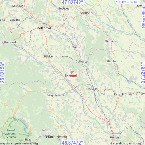
| Upper-left | 47.82742°, | 25.82156° |
| Center: | 47.35322°, | 26.52468° |
| Lower-right: | 46.87472°, | 27.22781° |
| Map W x H: | 105.9×105.9 km | = 65.8×65.8mi |
| max Lat: | 48.23793° ⇑12.1% North |
| Iorcani: | 47.35322° |
| min Lat: | ⇓87.9% South 43.65638° |
| min Long | Iorcani | max Long |
| 20.31667° | 26.52468° | 29.65403° |
| W 73.2%⇐ | ⇒26.8% E |
Elevation
Elevation of Iorcani is 400 m = 1312 ft, and this is 145.1 m = 476 ft above average elevation for this country.
| Max E: |
1278 m = 4193 ft | 19.3% |
| Iorcani | 400 m 1312 ft | |
| Avg. | 254.9 m = 836 ft | |
Min E: |
-2 m = -7 ft | 80.7% |
See also: Romania elevation on elevation.city.
Geographical zone
Iorcani is located in North temperate zone (between Tropic of Cancer and the Arctic Circle). Distance of this North polar circle is 2136 km =1327.2 mi to North.| Distance of | km | miles | from Iorcani |
|---|---|---|---|
| North Pole | 4741.9 | 2946.5 | to North |
| Arctic Circle | 2136 | 1327.2 | to North |
| Tropic Cancer | 2659.3 | 1652.4 | to South |
| Equator | 5265.2 | 3271.6 | to South |


Nearby cities:
15 places around Iorcani: (largest is in red/bold)
• Boura
6.8 km =4.2 mi,  330°
330°
• Broșteni
5.9 km =3.7 mi,  156°
156°
• Cristeşti
10.1 km =6.3 mi, 161°
• Dolheștii Mici
9.5 km =5.9 mi,  12°
12°
• Drăguşeni
8.4 km =5.2 mi,  201°
201°
• Forăşti
4.4 km =2.7 mi,  265°
265°
• Gulia
9.1 km =5.7 mi,  43°
43°
• Manolea
7 km =4.3 mi,  319°
319°
• Nigotești
7.5 km =4.7 mi,  296°
296°
• Oniceni
5.7 km =3.5 mi,  235°
235°
• Pietrosu
6.4 km =4 mi,  102°
102°
• Probota
7.9 km =4.9 mi,  71°
71°
• Tătăruşi
5.7 km =3.5 mi,  93°
93°
• Uda
4 km =2.5 mi,  117°
117°
• Valea Bourei
8.1 km =5 mi,  350°
350°
Sources, notices
• [Note1] Compared only with cities in Romania existing in our database
• [Src1] Map data: © OpenStreetMap contributors (CC-BY-SA)
• [Src2] Other city data from geonames.org with taken over terms of usage.
• [Src3] Geographical zone / Annual Mean Temperature by Robert A. Rohde @ Wikipedia
