Forăşti geodata
Forăşti (Suceava) is a seat of a second-order administrative division; located in Romania in Europe/Bucharest (GMT+3) time zone. With population of 4,912 people, there are 818 cities with bigger population in this country. Compared to other cities in Romania, 87.6% of cities are located further ↓South; 71.9% of cities are located further ←West and 78.3% of cities have lower elevation than Forăşti. Note1


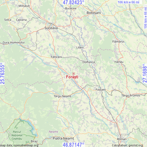
Forăşti GPS coordinates[2]
47° 21' 0" North, 26° 28' 0.012" East
| Map corner | latitude | longitude |
|---|---|---|
| Upper-left | 47.82423°, | 25.76355° |
| Center: | 47.35°, | 26.46667° |
| Lower-right: | 46.87147°, | 27.1698° |
| Map W x H: | 105.9×105.9 km | = 65.8×65.8mi |
| max Lat: | 48.23793° ⇑12.4% North |
| Forăşti: | 47.35° |
| min Lat: | ⇓87.6% South 43.65638° |
| min Long | Forăşti | max Long |
| 20.31667° | 26.46667° | 29.65403° |
| W 71.9%⇐ | ⇒28.1% E |
Elevation
Elevation of Forăşti is 379 m = 1243 ft, and this is 124.1 m = 407 ft above average elevation for this country.
| Max E: |
1278 m = 4193 ft | 21.7% |
| Forăşti | 379 m 1243 ft | |
| Avg. | 254.9 m = 836 ft | |
Min E: |
-2 m = -7 ft | 78.3% |
See also: Romania elevation on elevation.city.
Geographical zone
Forăşti is located in North temperate zone (between Tropic of Cancer and the Arctic Circle). Distance of this North polar circle is 2136.3 km =1327.4 mi to North.| Distance of | km | miles | from Forăşti |
|---|---|---|---|
| North Pole | 4742.2 | 2946.7 | to North |
| Arctic Circle | 2136.3 | 1327.4 | to North |
| Tropic Cancer | 2658.9 | 1652.2 | to South |
| Equator | 5264.8 | 3271.4 | to South |


Nearby cities:
15 places around Forăşti: (largest is in red/bold)
• Boura
6.3 km =3.9 mi,  9°
9°
• Broșteni
8.4 km =5.2 mi,  126°
126°
• Bărăști
8.6 km =5.3 mi,  279°
279°
• Drăguşeni
7.5 km =4.7 mi,  170°
170°
• Drăgănești
6.5 km =4 mi,  225°
225°
• Giulești
6.5 km =4 mi,  268°
268°
• Iorcani
4.4 km =2.7 mi,  85°
85°
• Manolea
5.7 km =3.5 mi,  358°
358°
• Nigotești
4.4 km =2.7 mi,  326°
326°
• Oniceni
2.9 km =1.8 mi,  186°
186°
• Târzia
9 km =5.6 mi,  243°
243°
• Uda
8.1 km =5 mi,  100°
100°
• Ungheni
9.5 km =5.9 mi,  183°
183°
• Vadu Moldovei
8.4 km =5.2 mi,  296°
296°
• Valea Bourei
8.9 km =5.5 mi,  19°
19°
Sources, notices
• [Note1] Compared only with cities in Romania existing in our database
• [Src1] Map data: © OpenStreetMap contributors (CC-BY-SA)
• [Src2] Other city data from geonames.org with taken over terms of usage.
• [Src3] Geographical zone / Annual Mean Temperature by Robert A. Rohde @ Wikipedia
