Oniceni geodata
Oniceni (Suceava) is a populated place; located in Romania in Europe/Bucharest (GMT+3) time zone. With population of 1,021 people, there are 4218 cities with bigger population in this country. Compared to other cities in Romania, 87.2% of cities are located further ↓South; 71.8% of cities are located further ←West and 70.2% of cities have lower elevation than Oniceni. Note1


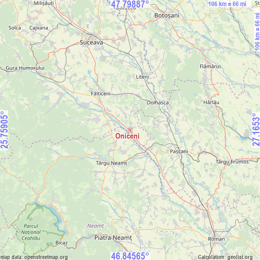
Oniceni GPS coordinates[2]
47° 19' 27.876" North, 26° 27' 43.812" East
| Map corner | latitude | longitude |
|---|---|---|
| Upper-left | 47.79887°, | 25.75905° |
| Center: | 47.32441°, | 26.46217° |
| Lower-right: | 46.84565°, | 27.1653° |
| Map W x H: | 106×106 km | = 65.9×65.9mi |
| max Lat: | 48.23793° ⇑12.8% North |
| Oniceni: | 47.32441° |
| min Lat: | ⇓87.2% South 43.65638° |
| min Long | Oniceni | max Long |
| 20.31667° | 26.46217° | 29.65403° |
| W 71.8%⇐ | ⇒28.2% E |
Elevation
Elevation of Oniceni is 322 m = 1056 ft, and this is 67.1 m = 220 ft above average elevation for this country.
| Max E: |
1278 m = 4193 ft | 29.8% |
| Oniceni | 322 m 1056 ft | |
| Avg. | 254.9 m = 836 ft | |
Min E: |
-2 m = -7 ft | 70.2% |
See also: Romania elevation on elevation.city.
Geographical zone
Oniceni is located in North temperate zone (between Tropic of Cancer and the Arctic Circle). Distance of this North polar circle is 2139.2 km =1329.2 mi to North.| Distance of | km | miles | from Oniceni |
|---|---|---|---|
| North Pole | 4745.1 | 2948.5 | to North |
| Arctic Circle | 2139.2 | 1329.2 | to North |
| Tropic Cancer | 2656.1 | 1650.4 | to South |
| Equator | 5262 | 3269.7 | to South |


Nearby cities:
15 places around Oniceni: (largest is in red/bold)
• Broșteni
7.4 km =4.6 mi,  107°
107°
• Brusturi
7.5 km =4.7 mi,  232°
232°
• Drăguşeni
4.8 km =3 mi,  160°
160°
• Drăgănești
4.6 km =2.9 mi,  247°
247°
• Forăşti
2.9 km =1.8 mi,  6°
6°
• Giulești
6.8 km =4.2 mi,  293°
293°
• Iorcani
5.7 km =3.5 mi,  55°
55°
• Manolea
8.6 km =5.3 mi,  1°
1°
• Nigotești
6.8 km =4.2 mi,  342°
342°
• Poiana
8.2 km =5.1 mi, 248°
• Preutești
8.6 km =5.3 mi,  152°
152°
• Răuceşti
9 km =5.6 mi,  202°
202°
• Târzia
7.8 km =4.8 mi,  260°
260°
• Uda
8.4 km =5.2 mi,  80°
80°
• Ungheni
6.6 km =4.1 mi,  181°
181°
Sources, notices
• [Note1] Compared only with cities in Romania existing in our database
• [Src1] Map data: © OpenStreetMap contributors (CC-BY-SA)
• [Src2] Other city data from geonames.org with taken over terms of usage.
• [Src3] Geographical zone / Annual Mean Temperature by Robert A. Rohde @ Wikipedia
