Igneşti geodata
Igneşti (Arad) is a seat of a second-order administrative division; located in Romania in Europe/Bucharest (GMT+3) time zone. With population of 809 people, there are 4997 cities with bigger population in this country. Compared to other cities in Romania, 64.5% of cities are located further ↓South; 93.1% of cities are located further →East and 59.5% of cities have higher elevation than Igneşti. Note1


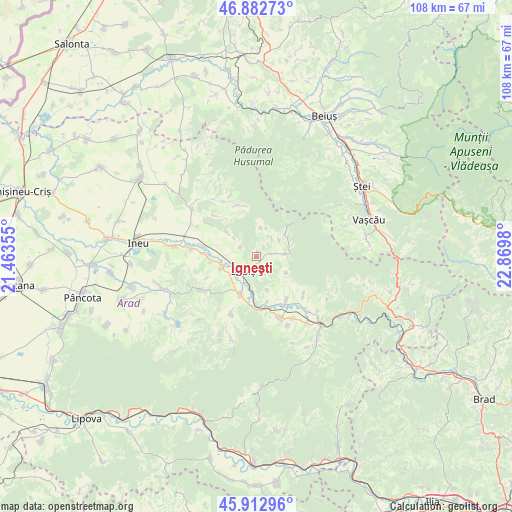
Igneşti GPS coordinates[2]
46° 24' 0" North, 22° 10' 0.012" East
| Map corner | latitude | longitude |
|---|---|---|
| Upper-left | 46.88273°, | 21.46355° |
| Center: | 46.4°, | 22.16667° |
| Lower-right: | 45.91296°, | 22.8698° |
| Map W x H: | 107.8×107.8 km | = 67×67mi |
| max Lat: | 48.23793° ⇑35.5% North |
| Igneşti: | 46.4° |
| min Lat: | ⇓64.5% South 43.65638° |
| min Long | Igneşti | max Long |
| 20.31667° | 22.16667° | 29.65403° |
| W 6.9%⇐ | ⇒93.1% E |
Elevation
Elevation of Igneşti is 168 m = 551 ft, and this is 86.9 m = 285 ft below average elevation for this country.
| Max E: |
1278 m = 4193 ft | 59.5% |
| Avg. | 254.9 m = 836 ft | |
| Igneşti | 168 m = 551 ft | |
Min E: |
-2 m = -7 ft | 40.5% |
See also: Romania elevation on elevation.city.
Geographical zone
Igneşti is located in North temperate zone (between Tropic of Cancer and the Arctic Circle). Distance of this North polar circle is 2242 km =1393.1 mi to North.| Distance of | km | miles | from Igneşti |
|---|---|---|---|
| North Pole | 4847.9 | 3012.3 | to North |
| Arctic Circle | 2242 | 1393.1 | to North |
| Tropic Cancer | 2553.3 | 1586.5 | to South |
| Equator | 5159.2 | 3205.8 | to South |


Nearby cities:
15 places around Igneşti: (largest is in red/bold)
• Aldești
9.6 km =6 mi,  266°
266°
• Archiş
12.9 km =8 mi,  316°
316°
• Buteni
10 km =6.2 mi,  202°
202°
• Bârsa
7.9 km =4.9 mi,  256°
256°
• Crocna
12.8 km =8 mi,  129°
129°
• Cărand
8.5 km =5.3 mi,  311°
311°
• Dezna
6.4 km =4 mi,  90°
90°
• Dieci
11.3 km =7 mi,  145°
145°
• Groșeni
11.5 km =7.1 mi,  341°
341°
• Hășmaș
12.8 km =8 mi,  330°
330°
• Moneasa
8.5 km =5.3 mi,  48°
48°
• Prunișor
4 km =2.5 mi,  301°
301°
• Răpsig
11.4 km =7.1 mi,  281°
281°
• Sebiş
5.3 km =3.3 mi,  225°
225°
• Seliștea
13 km =8.1 mi, 304°
Sources, notices
• [Note1] Compared only with cities in Romania existing in our database
• [Src1] Map data: © OpenStreetMap contributors (CC-BY-SA)
• [Src2] Other city data from geonames.org with taken over terms of usage.
• [Src3] Geographical zone / Annual Mean Temperature by Robert A. Rohde @ Wikipedia
