Seliștea geodata
Seliștea (Arad) is a populated place; located in Romania in Europe/Bucharest (GMT+3) time zone. With population of 594 people, there are 6243 cities with bigger population in this country. Compared to other cities in Romania, 66.2% of cities are located further ↓South; 94.2% of cities are located further →East and 67.7% of cities have higher elevation than Seliștea. Note1


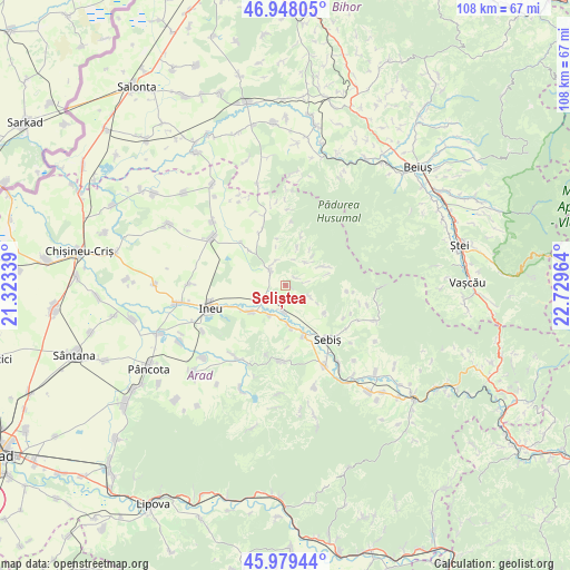
Seliștea GPS coordinates[2]
46° 27' 57.24" North, 22° 1' 35.436" East
| Map corner | latitude | longitude |
|---|---|---|
| Upper-left | 46.94805°, | 21.32339° |
| Center: | 46.4659°, | 22.02651° |
| Lower-right: | 45.97944°, | 22.72964° |
| Map W x H: | 107.7×107.7 km | = 66.9×66.9mi |
| max Lat: | 48.23793° ⇑33.8% North |
| Seliștea: | 46.4659° |
| min Lat: | ⇓66.2% South 43.65638° |
| min Long | Seliștea | max Long |
| 20.31667° | 22.02651° | 29.65403° |
| W 5.8%⇐ | ⇒94.2% E |
Elevation
Elevation of Seliștea is 136 m = 446 ft, and this is 118.9 m = 390 ft below average elevation for this country.
| Max E: |
1278 m = 4193 ft | 67.7% |
| Avg. | 254.9 m = 836 ft | |
| Seliștea | 136 m = 446 ft | |
Min E: |
-2 m = -7 ft | 32.3% |
See also: Romania elevation on elevation.city.
Geographical zone
Seliștea is located in North temperate zone (between Tropic of Cancer and the Arctic Circle). Distance of this North polar circle is 2234.7 km =1388.6 mi to North.| Distance of | km | miles | from Seliștea |
|---|---|---|---|
| North Pole | 4840.5 | 3007.7 | to North |
| Arctic Circle | 2234.7 | 1388.6 | to North |
| Tropic Cancer | 2560.6 | 1591.1 | to South |
| Equator | 5166.5 | 3210.3 | to South |


Nearby cities:
15 places around Seliștea: (largest is in red/bold)
• Aldești
8 km =5 mi,  171°
171°
• Archiş
2.6 km =1.6 mi,  42°
42°
• Beliu
3.8 km =2.4 mi,  300°
300°
• Bocsig
8 km =5 mi,  226°
226°
• Bârsa
9.7 km =6 mi,  161°
161°
• Chișlaca
11 km =6.8 mi,  333°
333°
• Craiva
13.8 km =8.6 mi,  340°
340°
• Cărand
4.7 km =2.9 mi,  112°
112°
• Groșeni
7.9 km =4.9 mi,  63°
63°
• Hășmaș
5.8 km =3.6 mi,  48°
48°
• Igneşti
13 km =8.1 mi,  124°
124°
• Prunișor
9 km =5.6 mi,  125°
125°
• Răpsig
5 km =3.1 mi,  184°
184°
• Sebiş
13 km =8.1 mi,  147°
147°
• Tăgădău
5 km =3.1 mi, 335°
Sources, notices
• [Note1] Compared only with cities in Romania existing in our database
• [Src1] Map data: © OpenStreetMap contributors (CC-BY-SA)
• [Src2] Other city data from geonames.org with taken over terms of usage.
• [Src3] Geographical zone / Annual Mean Temperature by Robert A. Rohde @ Wikipedia
