Prunișor geodata
Prunișor (Arad) is a populated place; located in Romania in Europe/Bucharest (GMT+3) time zone. With population of 619 people, there are 6080 cities with bigger population in this country. Compared to other cities in Romania, 65.1% of cities are located further ↓South; 93.4% of cities are located further →East and 65.4% of cities have higher elevation than Prunișor. Note1


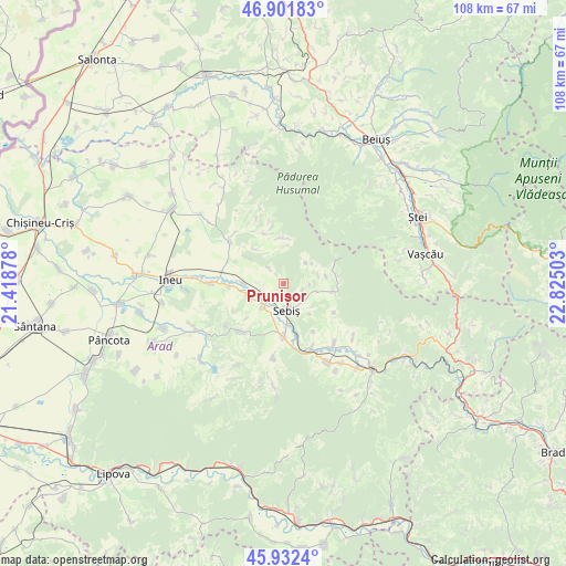
Prunișor GPS coordinates[2]
46° 25' 9.372" North, 22° 7' 18.84" East
| Map corner | latitude | longitude |
|---|---|---|
| Upper-left | 46.90183°, | 21.41878° |
| Center: | 46.41927°, | 22.1219° |
| Lower-right: | 45.9324°, | 22.82503° |
| Map W x H: | 107.8×107.8 km | = 67×67mi |
| max Lat: | 48.23793° ⇑34.9% North |
| Prunișor: | 46.41927° |
| min Lat: | ⇓65.1% South 43.65638° |
| min Long | Prunișor | max Long |
| 20.31667° | 22.1219° | 29.65403° |
| W 6.6%⇐ | ⇒93.4% E |
Elevation
Elevation of Prunișor is 145 m = 476 ft, and this is 109.9 m = 361 ft below average elevation for this country.
| Max E: |
1278 m = 4193 ft | 65.4% |
| Avg. | 254.9 m = 836 ft | |
| Prunișor | 145 m = 476 ft | |
Min E: |
-2 m = -7 ft | 34.6% |
See also: Romania elevation on elevation.city.
Geographical zone
Prunișor is located in North temperate zone (between Tropic of Cancer and the Arctic Circle). Distance of this North polar circle is 2239.8 km =1391.7 mi to North.| Distance of | km | miles | from Prunișor |
|---|---|---|---|
| North Pole | 4845.7 | 3011 | to North |
| Arctic Circle | 2239.8 | 1391.7 | to North |
| Tropic Cancer | 2555.4 | 1587.9 | to South |
| Equator | 5161.3 | 3207.1 | to South |


Nearby cities:
15 places around Prunișor: (largest is in red/bold)
• Aldești
6.7 km =4.2 mi,  245°
245°
• Archiş
9 km =5.6 mi,  322°
322°
• Beliu
12.8 km =8 mi,  303°
303°
• Buteni
11.4 km =7.1 mi,  182°
182°
• Bârsa
5.8 km =3.6 mi,  226°
226°
• Cuied
11.8 km =7.3 mi,  220°
220°
• Cărand
4.5 km =2.8 mi, 319°
• Dezna
10.1 km =6.3 mi,  102°
102°
• Groșeni
8.7 km =5.4 mi,  358°
358°
• Hășmaș
9.4 km =5.8 mi,  341°
341°
• Igneşti
4 km =2.5 mi,  121°
121°
• Moneasa
10.4 km =6.5 mi,  70°
70°
• Răpsig
7.7 km =4.8 mi,  271°
271°
• Sebiş
5.9 km =3.7 mi, 183°
• Seliștea
9 km =5.6 mi,  305°
305°
Sources, notices
• [Note1] Compared only with cities in Romania existing in our database
• [Src1] Map data: © OpenStreetMap contributors (CC-BY-SA)
• [Src2] Other city data from geonames.org with taken over terms of usage.
• [Src3] Geographical zone / Annual Mean Temperature by Robert A. Rohde @ Wikipedia
