Iegheriște geodata
Iegheriște (Satu Mare) is a populated place; located in Romania in Europe/Bucharest (GMT+3) time zone. With population of 629 people, there are 6012 cities with bigger population in this country. Compared to other cities in Romania, 94.2% of cities are located further ↓South; 80.7% of cities are located further →East and 58.7% of cities have higher elevation than Iegheriște. Note1


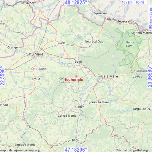
Iegheriște GPS coordinates[2]
47° 39' 28.08" North, 23° 15' 45.792" East
| Map corner | latitude | longitude |
|---|---|---|
| Upper-left | 48.12925°, | 22.5596° |
| Center: | 47.6578°, | 23.26272° |
| Lower-right: | 47.18206°, | 23.96585° |
| Map W x H: | 105.3×105.3 km | = 65.4×65.4mi |
| max Lat: | 48.23793° ⇑5.8% North |
| Iegheriște: | 47.6578° |
| min Lat: | ⇓94.2% South 43.65638° |
| min Long | Iegheriște | max Long |
| 20.31667° | 23.26272° | 29.65403° |
| W 19.3%⇐ | ⇒80.7% E |
Elevation
Elevation of Iegheriște is 171 m = 561 ft, and this is 83.9 m = 275 ft below average elevation for this country.
| Max E: |
1278 m = 4193 ft | 58.7% |
| Avg. | 254.9 m = 836 ft | |
| Iegheriște | 171 m = 561 ft | |
Min E: |
-2 m = -7 ft | 41.3% |
See also: Romania elevation on elevation.city.
Geographical zone
Iegheriște is located in North temperate zone (between Tropic of Cancer and the Arctic Circle). Distance of this North polar circle is 2102.1 km =1306.2 mi to North.| Distance of | km | miles | from Iegheriște |
|---|---|---|---|
| North Pole | 4708 | 2925.4 | to North |
| Arctic Circle | 2102.1 | 1306.2 | to North |
| Tropic Cancer | 2693.1 | 1673.4 | to South |
| Equator | 5299.1 | 3292.7 | to South |


Nearby cities:
15 places around Iegheriște: (largest is in red/bold)
• Ardusat
7.8 km =4.8 mi,  96°
96°
• Borlești
5.9 km =3.7 mi,  67°
67°
• Buzești
8.9 km =5.5 mi,  128°
128°
• Bârsău de Jos
7 km =4.3 mi,  179°
179°
• Bârsău de Sus
7.3 km =4.5 mi,  208°
208°
• Crucişor
3 km =1.9 mi,  341°
341°
• Fărcaşa
9.8 km =6.1 mi,  147°
147°
• Ilba
9.4 km =5.8 mi,  49°
49°
• Poiana Codrului
3.6 km =2.2 mi,  194°
194°
• Pomi
6.2 km =3.9 mi,  40°
40°
• Roșiori
6.3 km =3.9 mi,  347°
347°
• Seini
10.4 km =6.5 mi,  8°
8°
• Sârbi
9.3 km =5.8 mi,  139°
139°
• Săbișa
9.4 km =5.8 mi,  31°
31°
• Valea Vinului
8.8 km =5.5 mi,  317°
317°
Sources, notices
• [Note1] Compared only with cities in Romania existing in our database
• [Src1] Map data: © OpenStreetMap contributors (CC-BY-SA)
• [Src2] Other city data from geonames.org with taken over terms of usage.
• [Src3] Geographical zone / Annual Mean Temperature by Robert A. Rohde @ Wikipedia
