Fărcaşa geodata
Fărcaşa (Maramureş) is a seat of a second-order administrative division; located in Romania in Europe/Bucharest (GMT+3) time zone. With population of 3,716 people, there are 1314 cities with bigger population in this country. Compared to other cities in Romania, 92.7% of cities are located further ↓South; 79.5% of cities are located further →East and 61.7% of cities have higher elevation than Fărcaşa. Note1


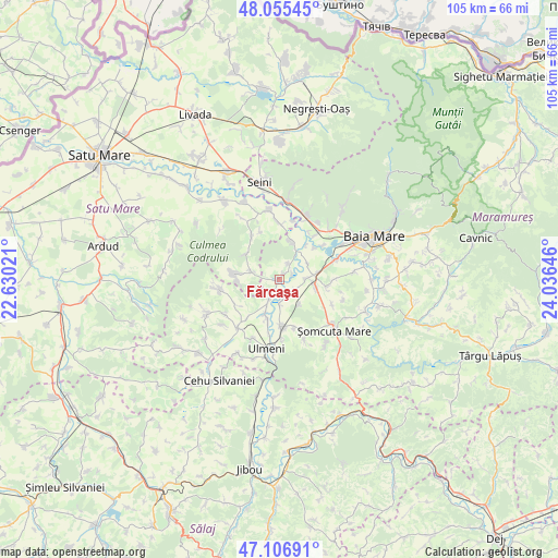
Fărcaşa GPS coordinates[2]
47° 34' 59.988" North, 23° 19' 59.988" East
| Map corner | latitude | longitude |
|---|---|---|
| Upper-left | 48.05545°, | 22.63021° |
| Center: | 47.58333°, | 23.33333° |
| Lower-right: | 47.10691°, | 24.03646° |
| Map W x H: | 105.5×105.5 km | = 65.6×65.6mi |
| max Lat: | 48.23793° ⇑7.3% North |
| Fărcaşa: | 47.58333° |
| min Lat: | ⇓92.7% South 43.65638° |
| min Long | Fărcaşa | max Long |
| 20.31667° | 23.33333° | 29.65403° |
| W 20.5%⇐ | ⇒79.5% E |
Elevation
Elevation of Fărcaşa is 160 m = 525 ft, and this is 94.9 m = 311 ft below average elevation for this country.
| Max E: |
1278 m = 4193 ft | 61.7% |
| Avg. | 254.9 m = 836 ft | |
| Fărcaşa | 160 m = 525 ft | |
Min E: |
-2 m = -7 ft | 38.3% |
See also: Romania elevation on elevation.city.
Geographical zone
Fărcaşa is located in North temperate zone (between Tropic of Cancer and the Arctic Circle). Distance of this North polar circle is 2110.4 km =1311.3 mi to North.| Distance of | km | miles | from Fărcaşa |
|---|---|---|---|
| North Pole | 4716.3 | 2930.6 | to North |
| Arctic Circle | 2110.4 | 1311.3 | to North |
| Tropic Cancer | 2684.9 | 1668.3 | to South |
| Equator | 5290.8 | 3287.5 | to South |


Nearby cities:
15 places around Fărcaşa: (largest is in red/bold)
• Ardusat
7.8 km =4.8 mi,  18°
18°
• Buzești
3.2 km =2 mi,  31°
31°
• Bârsău de Jos
5.4 km =3.4 mi,  284°
284°
• Bârsău de Sus
8.9 km =5.5 mi, 281°
• Fersig
6.1 km =3.8 mi,  141°
141°
• Gârdani
4 km =2.5 mi,  207°
207°
• Hideaga
6.6 km =4.1 mi,  82°
82°
• Lucăcești
4.8 km =3 mi,  178°
178°
• Mogoșești
4.9 km =3 mi,  92°
92°
• Poiana Codrului
7.9 km =4.9 mi,  307°
307°
• Pribilești
3.6 km =2.2 mi,  123°
123°
• Satulung
7.7 km =4.8 mi,  103°
103°
• Sârbi
1.4 km =0.9 mi, 32°
• Sălsig
6.1 km =3.8 mi,  204°
204°
• Tămaia
2.7 km =1.7 mi,  65°
65°
Sources, notices
• [Note1] Compared only with cities in Romania existing in our database
• [Src1] Map data: © OpenStreetMap contributors (CC-BY-SA)
• [Src2] Other city data from geonames.org with taken over terms of usage.
• [Src3] Geographical zone / Annual Mean Temperature by Robert A. Rohde @ Wikipedia
