Horia geodata
Horia (Tulcea) is a seat of a second-order administrative division; located in Romania in Europe/Bucharest (GMT+3) time zone. With population of 1,588 people, there are 3061 cities with bigger population in this country. Compared to other cities in Romania, 69.4% of cities are located further ↑North; 98.5% of cities are located further ←West and 72.7% of cities have higher elevation than Horia. Note1


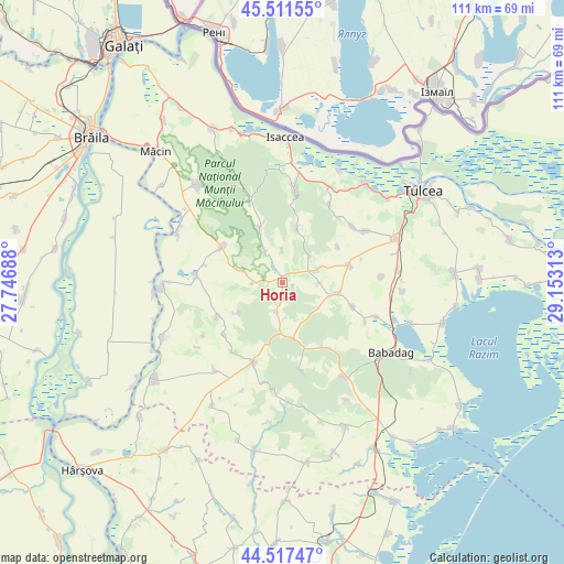
Horia GPS coordinates[2]
45° 1' 0.012" North, 28° 27' 0" East
| Map corner | latitude | longitude |
|---|---|---|
| Upper-left | 45.51155°, | 27.74688° |
| Center: | 45.01667°, | 28.45° |
| Lower-right: | 44.51747°, | 29.15313° |
| Map W x H: | 110.5×110.5 km | = 68.7×68.7mi |
| max Lat: | 48.23793° ⇑69.4% North |
| Horia: | 45.01667° |
| min Lat: | ⇓30.6% South 43.65638° |
| min Long | Horia | max Long |
| 20.31667° | 28.45° | 29.65403° |
| W 98.5%⇐ | ⇒1.5% E |
Elevation
Elevation of Horia is 118 m = 387 ft, and this is 136.9 m = 449 ft below average elevation for this country.
| Max E: |
1278 m = 4193 ft | 72.7% |
| Avg. | 254.9 m = 836 ft | |
| Horia | 118 m = 387 ft | |
Min E: |
-2 m = -7 ft | 27.3% |
See also: Romania elevation on elevation.city.
Geographical zone
Horia is located in North temperate zone (between Tropic of Cancer and the Arctic Circle). Distance of this North polar circle is 2395.8 km =1488.7 mi to North.| Distance of | km | miles | from Horia |
|---|---|---|---|
| North Pole | 5001.7 | 3107.9 | to North |
| Arctic Circle | 2395.8 | 1488.7 | to North |
| Tropic Cancer | 2399.5 | 1491 | to South |
| Equator | 5005.4 | 3110.2 | to South |


Nearby cities:
15 places around Horia: (largest is in red/bold)
• Cerna
12.8 km =8 mi,  305°
305°
• Ciucurova
9.6 km =6 mi,  164°
164°
• Cârjelari
10.5 km =6.5 mi,  234°
234°
• Dorobanţu
16.2 km =10.1 mi,  242°
242°
• Hamcearca
12.9 km =8 mi,  329°
329°
• Izvoarele
6.8 km =4.2 mi,  74°
74°
• Mihai Bravu
17.4 km =10.8 mi,  115°
115°
• Mircea Vodă
7.8 km =4.8 mi,  287°
287°
• Nalbant
13.6 km =8.5 mi, 74°
• Nicolae Bălcescu
11 km =6.8 mi,  101°
101°
• Slava Cercheză
14.9 km =9.3 mi,  149°
149°
• Topolog
16.2 km =10.1 mi,  203°
203°
• Traian
16.9 km =10.5 mi,  274°
274°
• Turda
14.4 km =8.9 mi,  108°
108°
• Valea Teilor
11 km =6.8 mi,  15°
15°
Sources, notices
• [Note1] Compared only with cities in Romania existing in our database
• [Src1] Map data: © OpenStreetMap contributors (CC-BY-SA)
• [Src2] Other city data from geonames.org with taken over terms of usage.
• [Src3] Geographical zone / Annual Mean Temperature by Robert A. Rohde @ Wikipedia
