Nalbant geodata
Nalbant (Tulcea) is a seat of a second-order administrative division; located in Romania in Europe/Bucharest (GMT+3) time zone. With population of 2,789 people, there are 1920 cities with bigger population in this country. Compared to other cities in Romania, 67.8% of cities are located further ↑North; 99.2% of cities are located further ←West and 87.8% of cities have higher elevation than Nalbant. Note1


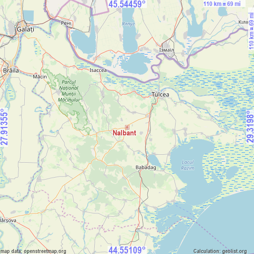
Nalbant GPS coordinates[2]
45° 3' 0" North, 28° 37' 0.012" East
| Map corner | latitude | longitude |
|---|---|---|
| Upper-left | 45.54459°, | 27.91355° |
| Center: | 45.05°, | 28.61667° |
| Lower-right: | 44.55109°, | 29.3198° |
| Map W x H: | 110.5×110.5 km | = 68.7×68.7mi |
| max Lat: | 48.23793° ⇑67.8% North |
| Nalbant: | 45.05° |
| min Lat: | ⇓32.2% South 43.65638° |
| min Long | Nalbant | max Long |
| 20.31667° | 28.61667° | 29.65403° |
| W 99.2%⇐ | ⇒0.8% E |
Elevation
Elevation of Nalbant is 68 m = 223 ft, and this is 186.9 m = 613 ft below average elevation for this country.
| Max E: |
1278 m = 4193 ft | 87.8% |
| Avg. | 254.9 m = 836 ft | |
| Nalbant | 68 m = 223 ft | |
Min E: |
-2 m = -7 ft | 12.2% |
See also: Romania elevation on elevation.city.
Geographical zone
Nalbant is located in North temperate zone (between Tropic of Cancer and the Arctic Circle). Distance of this North polar circle is 2392.1 km =1486.4 mi to North.| Distance of | km | miles | from Nalbant |
|---|---|---|---|
| North Pole | 4998 | 3105.6 | to North |
| Arctic Circle | 2392.1 | 1486.4 | to North |
| Tropic Cancer | 2403.2 | 1493.3 | to South |
| Equator | 5009.1 | 3112.5 | to South |


Nearby cities:
15 places around Nalbant: (largest is in red/bold)
• Cataloi
10.2 km =6.3 mi,  59°
59°
• Frecăţei
6.8 km =4.2 mi,  35°
35°
• Horia
13.6 km =8.5 mi,  254°
254°
• Izvoarele
6.8 km =4.2 mi, 254°
• Lăstuni
6.8 km =4.2 mi,  111°
111°
• Mihai Bravu
11.4 km =7.1 mi,  166°
166°
• Mihail Kogălniceanu
9.4 km =5.8 mi,  101°
101°
• Mineri
14.9 km =9.3 mi,  31°
31°
• Nicolae Bălcescu
6.3 km =3.9 mi,  201°
201°
• Poșta
7.3 km =4.5 mi,  5°
5°
• Rândunica
11.9 km =7.4 mi,  117°
117°
• Satu Nou
11.7 km =7.3 mi,  153°
153°
• Telița
12.1 km =7.5 mi,  341°
341°
• Turda
8.4 km =5.2 mi,  176°
176°
• Valea Teilor
12.2 km =7.6 mi,  304°
304°
Sources, notices
• [Note1] Compared only with cities in Romania existing in our database
• [Src1] Map data: © OpenStreetMap contributors (CC-BY-SA)
• [Src2] Other city data from geonames.org with taken over terms of usage.
• [Src3] Geographical zone / Annual Mean Temperature by Robert A. Rohde @ Wikipedia
