Izvoarele geodata
Izvoarele (Tulcea) is a seat of a second-order administrative division; located in Romania in Europe/Bucharest (GMT+3) time zone. With population of 3,817 people, there are 1254 cities with bigger population in this country. Compared to other cities in Romania, 68.5% of cities are located further ↑North; 98.8% of cities are located further ←West and 90.9% of cities have higher elevation than Izvoarele. Note1


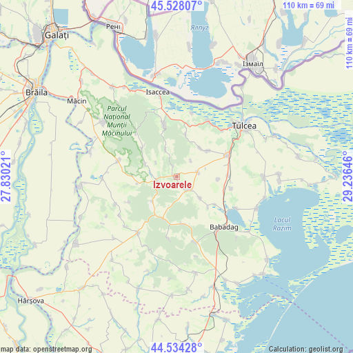
Izvoarele GPS coordinates[2]
45° 1' 59.988" North, 28° 31' 59.988" East
| Map corner | latitude | longitude |
|---|---|---|
| Upper-left | 45.52807°, | 27.83021° |
| Center: | 45.03333°, | 28.53333° |
| Lower-right: | 44.53428°, | 29.23646° |
| Map W x H: | 110.5×110.5 km | = 68.7×68.7mi |
| max Lat: | 48.23793° ⇑68.5% North |
| Izvoarele: | 45.03333° |
| min Lat: | ⇓31.5% South 43.65638° |
| min Long | Izvoarele | max Long |
| 20.31667° | 28.53333° | 29.65403° |
| W 98.8%⇐ | ⇒1.2% E |
Elevation
Elevation of Izvoarele is 54 m = 177 ft, and this is 200.9 m = 659 ft below average elevation for this country.
| Max E: |
1278 m = 4193 ft | 90.9% |
| Avg. | 254.9 m = 836 ft | |
| Izvoarele | 54 m = 177 ft | |
Min E: |
-2 m = -7 ft | 9.1% |
See also: Romania elevation on elevation.city.
Geographical zone
Izvoarele is located in North temperate zone (between Tropic of Cancer and the Arctic Circle). Distance of this North polar circle is 2393.9 km =1487.5 mi to North.| Distance of | km | miles | from Izvoarele |
|---|---|---|---|
| North Pole | 4999.8 | 3106.7 | to North |
| Arctic Circle | 2393.9 | 1487.5 | to North |
| Tropic Cancer | 2401.3 | 1492.1 | to South |
| Equator | 5007.2 | 3111.3 | to South |


Nearby cities:
15 places around Izvoarele: (largest is in red/bold)
• Ciucurova
11.8 km =7.3 mi,  199°
199°
• Frecăţei
12.8 km =8 mi,  54°
54°
• Horia
6.8 km =4.2 mi,  254°
254°
• Lăstuni
12.9 km =8 mi,  93°
93°
• Mihai Bravu
13 km =8.1 mi,  135°
135°
• Mihail Kogălniceanu
15.7 km =9.8 mi, 90°
• Mircea Vodă
14 km =8.7 mi,  271°
271°
• Nalbant
6.8 km =4.2 mi,  74°
74°
• Nicolae Bălcescu
5.9 km =3.7 mi,  133°
133°
• Poșta
11.7 km =7.3 mi,  38°
38°
• Satu Nou
14.6 km =9.1 mi, 125°
• Slava Cercheză
14.7 km =9.1 mi,  175°
175°
• Telița
13.6 km =8.5 mi,  11°
11°
• Turda
9.6 km =6 mi, 132°
• Valea Teilor
9.4 km =5.8 mi,  337°
337°
Sources, notices
• [Note1] Compared only with cities in Romania existing in our database
• [Src1] Map data: © OpenStreetMap contributors (CC-BY-SA)
• [Src2] Other city data from geonames.org with taken over terms of usage.
• [Src3] Geographical zone / Annual Mean Temperature by Robert A. Rohde @ Wikipedia
