Hârtoape geodata
Hârtoape (Iaşi) is a populated place; located in Romania in Europe/Bucharest (GMT+3) time zone. With population of 1,319 people, there are 3481 cities with bigger population in this country. Compared to other cities in Romania, 87.2% of cities are located further ↓South; 77.1% of cities are located further ←West and 55.8% of cities have lower elevation than Hârtoape. Note1


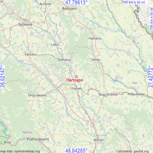
Hârtoape GPS coordinates[2]
47° 19' 17.904" North, 26° 43' 28.524" East
| Map corner | latitude | longitude |
|---|---|---|
| Upper-left | 47.79613°, | 26.02147° |
| Center: | 47.32164°, | 26.72459° |
| Lower-right: | 46.84285°, | 27.42772° |
| Map W x H: | 106×106 km | = 65.9×65.9mi |
| max Lat: | 48.23793° ⇑12.8% North |
| Hârtoape: | 47.32164° |
| min Lat: | ⇓87.2% South 43.65638° |
| min Long | Hârtoape | max Long |
| 20.31667° | 26.72459° | 29.65403° |
| W 77.1%⇐ | ⇒22.9% E |
Elevation
Elevation of Hârtoape is 242 m = 794 ft, and this is 12.9 m = 42 ft below average elevation for this country.
| Max E: |
1278 m = 4193 ft | 44.2% |
| Avg. | 254.9 m = 836 ft | |
| Hârtoape | 242 m = 794 ft | |
Min E: |
-2 m = -7 ft | 55.8% |
See also: Romania elevation on elevation.city.
Geographical zone
Hârtoape is located in North temperate zone (between Tropic of Cancer and the Arctic Circle). Distance of this North polar circle is 2139.5 km =1329.4 mi to North.| Distance of | km | miles | from Hârtoape |
|---|---|---|---|
| North Pole | 4745.4 | 2948.7 | to North |
| Arctic Circle | 2139.5 | 1329.4 | to North |
| Tropic Cancer | 2655.8 | 1650.2 | to South |
| Equator | 5261.7 | 3269.5 | to South |


Nearby cities:
15 places around Hârtoape: (largest is in red/bold)
• Bursuc-Deal
3.7 km =2.3 mi,  275°
275°
• Conțești
5.3 km =3.3 mi,  255°
255°
• Crivești
4.4 km =2.7 mi,  86°
86°
• Dumbrava
3.6 km =2.2 mi,  349°
349°
• Gura Bâdiliței
3.1 km =1.9 mi,  141°
141°
• Heci
5.3 km =3.3 mi,  297°
297°
• Hărmăneștii Vechi
8.3 km =5.2 mi,  126°
126°
• Lespezi
5.3 km =3.3 mi,  339°
339°
• Lunca
4.6 km =2.9 mi,  168°
168°
• Paşcani
8.3 km =5.2 mi,  180°
180°
• Sireţel
8.7 km =5.4 mi,  4°
4°
• Todireşti
8.2 km =5.1 mi, 93°
• Topile
7.7 km =4.8 mi,  212°
212°
• Valea Seacă
5.3 km =3.3 mi,  232°
232°
• Vânători
5.2 km =3.2 mi,  35°
35°
Sources, notices
• [Note1] Compared only with cities in Romania existing in our database
• [Src1] Map data: © OpenStreetMap contributors (CC-BY-SA)
• [Src2] Other city data from geonames.org with taken over terms of usage.
• [Src3] Geographical zone / Annual Mean Temperature by Robert A. Rohde @ Wikipedia
