Sireţel geodata
Sireţel (Iaşi) is a seat of a second-order administrative division; located in Romania in Europe/Bucharest (GMT+3) time zone. With population of 4,046 people, there are 1144 cities with bigger population in this country. Compared to other cities in Romania, 88.8% of cities are located further ↓South; 77.2% of cities are located further ←West and 59.4% of cities have lower elevation than Sireţel. Note1


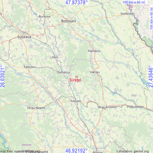
Sireţel GPS coordinates[2]
47° 24' 0" North, 26° 43' 59.988" East
| Map corner | latitude | longitude |
|---|---|---|
| Upper-left | 47.87378°, | 26.03021° |
| Center: | 47.4°, | 26.73333° |
| Lower-right: | 46.92192°, | 27.43646° |
| Map W x H: | 105.8×105.8 km | = 65.7×65.7mi |
| max Lat: | 48.23793° ⇑11.2% North |
| Sireţel: | 47.4° |
| min Lat: | ⇓88.8% South 43.65638° |
| min Long | Sireţel | max Long |
| 20.31667° | 26.73333° | 29.65403° |
| W 77.2%⇐ | ⇒22.8% E |
Elevation
Elevation of Sireţel is 260 m = 853 ft, and this is 5.1 m = 17 ft above average elevation for this country.
| Max E: |
1278 m = 4193 ft | 40.6% |
| Sireţel | 260 m 853 ft | |
| Avg. | 254.9 m = 836 ft | |
Min E: |
-2 m = -7 ft | 59.4% |
See also: Romania elevation on elevation.city.
Geographical zone
Sireţel is located in North temperate zone (between Tropic of Cancer and the Arctic Circle). Distance of this North polar circle is 2130.8 km =1324 mi to North.| Distance of | km | miles | from Sireţel |
|---|---|---|---|
| North Pole | 4736.7 | 2943.2 | to North |
| Arctic Circle | 2130.8 | 1324 | to North |
| Tropic Cancer | 2664.5 | 1655.6 | to South |
| Equator | 5270.4 | 3274.9 | to South |


Nearby cities:
15 places around Sireţel: (largest is in red/bold)
• Buda
4.2 km =2.6 mi,  274°
274°
• Budeni
5.8 km =3.6 mi,  285°
285°
• Bursuc-Deal
9.4 km =5.8 mi,  207°
207°
• Crivești
9.2 km =5.7 mi,  156°
156°
• Dumbrava
5.3 km =3.3 mi,  194°
194°
• Gulia
9.5 km =5.9 mi,  278°
278°
• Heci
8.3 km =5.2 mi,  220°
220°
• Humosu
6.3 km =3.9 mi,  0°
0°
• Hârtoape
8.7 km =5.4 mi,  184°
184°
• Lespezi
4.5 km =2.8 mi, 214°
• Probota
8.6 km =5.3 mi,  251°
251°
• Siliștea Nouă
9.2 km =5.7 mi,  307°
307°
• Slobozia
0.7 km =0.4 mi,  93°
93°
• Sticlăria
7.9 km =4.9 mi, 89°
• Vânători
5 km =3.1 mi,  152°
152°
Sources, notices
• [Note1] Compared only with cities in Romania existing in our database
• [Src1] Map data: © OpenStreetMap contributors (CC-BY-SA)
• [Src2] Other city data from geonames.org with taken over terms of usage.
• [Src3] Geographical zone / Annual Mean Temperature by Robert A. Rohde @ Wikipedia
