Paşcani geodata
Paşcani (Iaşi) is a seat of a second-order administrative division; located in Romania in Europe/Bucharest (GMT+3) time zone. With population of 45,000 people, there are 50 cities with bigger population in this country. Compared to other cities in Romania, 85.2% of cities are located further ↓South; 77.1% of cities are located further ←West and 55.8% of cities have lower elevation than Paşcani. Note1


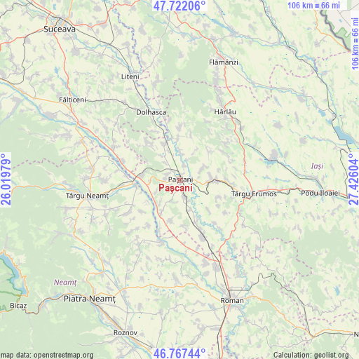
Paşcani GPS coordinates[2]
47° 14' 48.84" North, 26° 43' 22.476" East
| Map corner | latitude | longitude |
|---|---|---|
| Upper-left | 47.72206°, | 26.01979° |
| Center: | 47.2469°, | 26.72291° |
| Lower-right: | 46.76744°, | 27.42604° |
| Map W x H: | 106.1×106.1 km | = 65.9×65.9mi |
| max Lat: | 48.23793° ⇑14.8% North |
| Paşcani: | 47.2469° |
| min Lat: | ⇓85.2% South 43.65638° |
| min Long | Paşcani | max Long |
| 20.31667° | 26.72291° | 29.65403° |
| W 77.1%⇐ | ⇒22.9% E |
Elevation
Elevation of Paşcani is 242 m = 794 ft, and this is 12.9 m = 42 ft below average elevation for this country.
| Max E: |
1278 m = 4193 ft | 44.2% |
| Avg. | 254.9 m = 836 ft | |
| Paşcani | 242 m = 794 ft | |
Min E: |
-2 m = -7 ft | 55.8% |
See also: Paşcani elevation on elevation.city.
Geographical zone
Paşcani is located in North temperate zone (between Tropic of Cancer and the Arctic Circle). Distance of this North polar circle is 2147.8 km =1334.6 mi to North.| Distance of | km | miles | from Paşcani |
|---|---|---|---|
| North Pole | 4753.7 | 2953.8 | to North |
| Arctic Circle | 2147.8 | 1334.6 | to North |
| Tropic Cancer | 2647.4 | 1645 | to South |
| Equator | 5253.4 | 3264.3 | to South |


Nearby cities:
15 places around Paşcani: (largest is in red/bold)
• Boureni
7.9 km =4.9 mi,  241°
241°
• Brătești
6.8 km =4.2 mi,  204°
204°
• Conțești
8.6 km =5.3 mi,  324°
324°
• Dumbrăvița
9 km =5.6 mi,  84°
84°
• Gura Bâdiliței
6.2 km =3.9 mi,  19°
19°
• Hârtoape
8.3 km =5.2 mi,  0°
0°
• Hărmăneștii Noi
5.8 km =3.6 mi, 83°
• Hărmăneștii Vechi
7.7 km =4.8 mi,  63°
63°
• Lunca
4 km =2.5 mi, 15°
• Moţca
8 km =5 mi,  272°
272°
• Soci
9 km =5.6 mi,  221°
221°
• Sodomeni
3.8 km =2.4 mi, 223°
• Stolniceni-Prăjescu
5.7 km =3.5 mi,  160°
160°
• Topile
4.5 km =2.8 mi,  294°
294°
• Valea Seacă
6.5 km =4 mi, 320°
Sources, notices
• [Note1] Compared only with cities in Romania existing in our database
• [Src1] Map data: © OpenStreetMap contributors (CC-BY-SA)
• [Src2] Other city data from geonames.org with taken over terms of usage.
• [Src3] Geographical zone / Annual Mean Temperature by Robert A. Rohde @ Wikipedia
