Hârlău geodata
Hârlău (Iaşi) is a seat of a second-order administrative division; located in Romania in Europe/Bucharest (GMT+3) time zone. With population of 11,295 people, there are 177 cities with bigger population in this country. Compared to other cities in Romania, 89.5% of cities are located further ↓South; 80.9% of cities are located further ←West and 63.4% of cities have higher elevation than Hârlău. Note1


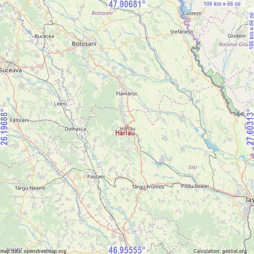
Hârlău GPS coordinates[2]
47° 25' 59.988" North, 26° 54' 0" East
| Map corner | latitude | longitude |
|---|---|---|
| Upper-left | 47.90681°, | 26.19688° |
| Center: | 47.43333°, | 26.9° |
| Lower-right: | 46.95555°, | 27.60313° |
| Map W x H: | 105.8×105.8 km | = 65.7×65.7mi |
| max Lat: | 48.23793° ⇑10.5% North |
| Hârlău: | 47.43333° |
| min Lat: | ⇓89.5% South 43.65638° |
| min Long | Hârlău | max Long |
| 20.31667° | 26.9° | 29.65403° |
| W 80.9%⇐ | ⇒19.1% E |
Elevation
Elevation of Hârlău is 153 m = 502 ft, and this is 101.9 m = 334 ft below average elevation for this country.
| Max E: |
1278 m = 4193 ft | 63.4% |
| Avg. | 254.9 m = 836 ft | |
| Hârlău | 153 m = 502 ft | |
Min E: |
-2 m = -7 ft | 36.6% |
See also: Romania elevation on elevation.city.
Geographical zone
Hârlău is located in North temperate zone (between Tropic of Cancer and the Arctic Circle). Distance of this North polar circle is 2127.1 km =1321.7 mi to North.| Distance of | km | miles | from Hârlău |
|---|---|---|---|
| North Pole | 4733 | 2940.9 | to North |
| Arctic Circle | 2127.1 | 1321.7 | to North |
| Tropic Cancer | 2668.2 | 1657.9 | to South |
| Equator | 5274.1 | 3277.2 | to South |


Nearby cities:
15 places around Hârlău: (largest is in red/bold)
• Boscoteni
8.6 km =5.3 mi,  344°
344°
• Buhalnița
6.2 km =3.9 mi,  169°
169°
• Bădeni
4.8 km =3 mi,  129°
129°
• Deleni
3.9 km =2.4 mi, 341°
• Feredeni
5.7 km =3.5 mi,  345°
345°
• Fetești
2.8 km =1.7 mi, 165°
• Maxut
1 km =0.6 mi,  322°
322°
• Poiana
7.2 km =4.5 mi, 337°
• Poiana Mărului
6 km =3.7 mi,  185°
185°
• Pârcovaci
3.7 km =2.3 mi,  274°
274°
• Rădeni
8.7 km =5.4 mi,  356°
356°
• Scobinţi
6.1 km =3.8 mi,  155°
155°
• Slobozia
4.9 km =3 mi, 350°
• Sticlăria
5.9 km =3.7 mi,  232°
232°
• Zagavia
1.6 km =1 mi, 185°
Sources, notices
• [Note1] Compared only with cities in Romania existing in our database
• [Src1] Map data: © OpenStreetMap contributors (CC-BY-SA)
• [Src2] Other city data from geonames.org with taken over terms of usage.
• [Src3] Geographical zone / Annual Mean Temperature by Robert A. Rohde @ Wikipedia
