Sticlăria geodata
Sticlăria (Iaşi) is a populated place; located in Romania in Europe/Bucharest (GMT+3) time zone. With population of 1,625 people, there are 3011 cities with bigger population in this country. Compared to other cities in Romania, 88.9% of cities are located further ↓South; 79.5% of cities are located further ←West and 79.9% of cities have lower elevation than Sticlăria. Note1


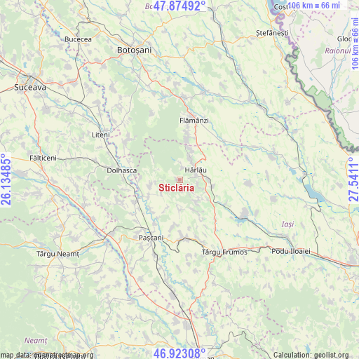
Sticlăria GPS coordinates[2]
47° 24' 4.14" North, 26° 50' 16.692" East
| Map corner | latitude | longitude |
|---|---|---|
| Upper-left | 47.87492°, | 26.13485° |
| Center: | 47.40115°, | 26.83797° |
| Lower-right: | 46.92308°, | 27.5411° |
| Map W x H: | 105.8×105.8 km | = 65.7×65.7mi |
| max Lat: | 48.23793° ⇑11.1% North |
| Sticlăria: | 47.40115° |
| min Lat: | ⇓88.9% South 43.65638° |
| min Long | Sticlăria | max Long |
| 20.31667° | 26.83797° | 29.65403° |
| W 79.5%⇐ | ⇒20.5% E |
Elevation
Elevation of Sticlăria is 393 m = 1289 ft, and this is 138.1 m = 453 ft above average elevation for this country.
| Max E: |
1278 m = 4193 ft | 20.1% |
| Sticlăria | 393 m 1289 ft | |
| Avg. | 254.9 m = 836 ft | |
Min E: |
-2 m = -7 ft | 79.9% |
See also: Romania elevation on elevation.city.
Geographical zone
Sticlăria is located in North temperate zone (between Tropic of Cancer and the Arctic Circle). Distance of this North polar circle is 2130.7 km =1324 mi to North.| Distance of | km | miles | from Sticlăria |
|---|---|---|---|
| North Pole | 4736.5 | 2943.1 | to North |
| Arctic Circle | 2130.7 | 1324 | to North |
| Tropic Cancer | 2664.6 | 1655.7 | to South |
| Equator | 5270.5 | 3274.9 | to South |


Nearby cities:
15 places around Sticlăria: (largest is in red/bold)
• Buhalnița
6.3 km =3.9 mi,  112°
112°
• Bădeni
8.4 km =5.2 mi,  86°
86°
• Cârjoaia
8.6 km =5.3 mi,  141°
141°
• Deleni
8 km =5 mi,  25°
25°
• Fetești
5.4 km =3.4 mi,  80°
80°
• Horodiștea
7.6 km =4.7 mi,  134°
134°
• Hârlău
5.9 km =3.7 mi,  52°
52°
• Maxut
6 km =3.7 mi,  42°
42°
• Poiana Mărului
4.8 km =3 mi,  120°
120°
• Pârcovaci
4 km =2.5 mi,  13°
13°
• Scobinţi
7.4 km =4.6 mi, 105°
• Sireţel
7.9 km =4.9 mi,  269°
269°
• Slobozia
7.2 km =4.5 mi, 268°
• Vânători
7.2 km =4.5 mi,  230°
230°
• Zagavia
4.9 km =3 mi,  66°
66°
Sources, notices
• [Note1] Compared only with cities in Romania existing in our database
• [Src1] Map data: © OpenStreetMap contributors (CC-BY-SA)
• [Src2] Other city data from geonames.org with taken over terms of usage.
• [Src3] Geographical zone / Annual Mean Temperature by Robert A. Rohde @ Wikipedia
