Larga-Jijia geodata
Larga-Jijia (Iaşi) is a populated place; located in Romania in Europe/Bucharest (GMT+3) time zone. With population of 720 people, there are 5464 cities with bigger population in this country. Compared to other cities in Romania, 87.1% of cities are located further ↓South; 89.5% of cities are located further ←West and 88.8% of cities have higher elevation than Larga-Jijia. Note1


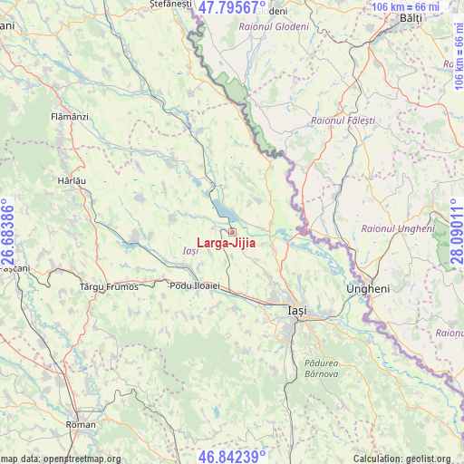
Larga-Jijia GPS coordinates[2]
47° 19' 16.248" North, 27° 23' 13.128" East
| Map corner | latitude | longitude |
|---|---|---|
| Upper-left | 47.79567°, | 26.68386° |
| Center: | 47.32118°, | 27.38698° |
| Lower-right: | 46.84239°, | 28.09011° |
| Map W x H: | 106×106 km | = 65.9×65.9mi |
| max Lat: | 48.23793° ⇑12.9% North |
| Larga-Jijia: | 47.32118° |
| min Lat: | ⇓87.1% South 43.65638° |
| min Long | Larga-Jijia | max Long |
| 20.31667° | 27.38698° | 29.65403° |
| W 89.5%⇐ | ⇒10.5% E |
Elevation
Elevation of Larga-Jijia is 64 m = 210 ft, and this is 190.9 m = 626 ft below average elevation for this country.
| Max E: |
1278 m = 4193 ft | 88.8% |
| Avg. | 254.9 m = 836 ft | |
| Larga-Jijia | 64 m = 210 ft | |
Min E: |
-2 m = -7 ft | 11.2% |
See also: Romania elevation on elevation.city.
Geographical zone
Larga-Jijia is located in North temperate zone (between Tropic of Cancer and the Arctic Circle). Distance of this North polar circle is 2139.6 km =1329.5 mi to North.| Distance of | km | miles | from Larga-Jijia |
|---|---|---|---|
| North Pole | 4745.4 | 2948.7 | to North |
| Arctic Circle | 2139.6 | 1329.5 | to North |
| Tropic Cancer | 2655.7 | 1650.2 | to South |
| Equator | 5261.6 | 3269.4 | to South |


Nearby cities:
15 places around Larga-Jijia: (largest is in red/bold)
• Avântu
7.2 km =4.5 mi,  191°
191°
• Borșa
10.7 km =6.6 mi,  350°
350°
• Cârniceni
9.1 km =5.7 mi,  77°
77°
• Forăști
8.6 km =5.3 mi,  295°
295°
• Gropniţa
10.8 km =6.7 mi,  287°
287°
• Iepureni
4.3 km =2.7 mi,  122°
122°
• Mihail Kogălniceanu
3.6 km =2.2 mi,  36°
36°
• Movileni
2.8 km =1.7 mi,  259°
259°
• Perieni
9.7 km =6 mi, 43°
• Popricani
10.1 km =6.3 mi,  103°
103°
• Potângeni
3.9 km =2.4 mi,  284°
284°
• Probota
11 km =6.8 mi,  50°
50°
• Româneşti
6.8 km =4.2 mi,  231°
231°
• Totoești
10.8 km =6.7 mi,  223°
223°
• Ţigănaşi
6.2 km =3.9 mi, 77°
Sources, notices
• [Note1] Compared only with cities in Romania existing in our database
• [Src1] Map data: © OpenStreetMap contributors (CC-BY-SA)
• [Src2] Other city data from geonames.org with taken over terms of usage.
• [Src3] Geographical zone / Annual Mean Temperature by Robert A. Rohde @ Wikipedia
