Glăvăneşti geodata
Glăvăneşti (Bacău) is a seat of a second-order administrative division; located in Romania in Europe/Bucharest (GMT+3) time zone. With population of 3,760 people, there are 1291 cities with bigger population in this country. Compared to other cities in Romania, 60.8% of cities are located further ↓South; 89.4% of cities are located further ←West and 57.1% of cities have lower elevation than Glăvăneşti. Note1


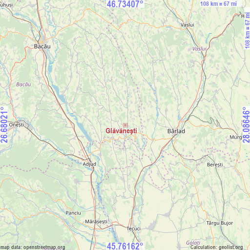
Glăvăneşti GPS coordinates[2]
46° 15' 0" North, 27° 22' 59.988" East
| Map corner | latitude | longitude |
|---|---|---|
| Upper-left | 46.73407°, | 26.68021° |
| Center: | 46.25°, | 27.38333° |
| Lower-right: | 45.76162°, | 28.08646° |
| Map W x H: | 108.1×108.1 km | = 67.2×67.2mi |
| max Lat: | 48.23793° ⇑39.2% North |
| Glăvăneşti: | 46.25° |
| min Lat: | ⇓60.8% South 43.65638° |
| min Long | Glăvăneşti | max Long |
| 20.31667° | 27.38333° | 29.65403° |
| W 89.4%⇐ | ⇒10.6% E |
Elevation
Elevation of Glăvăneşti is 248 m = 814 ft, and this is 6.9 m = 23 ft below average elevation for this country.
| Max E: |
1278 m = 4193 ft | 42.9% |
| Avg. | 254.9 m = 836 ft | |
| Glăvăneşti | 248 m = 814 ft | |
Min E: |
-2 m = -7 ft | 57.1% |
See also: Romania elevation on elevation.city.
Geographical zone
Glăvăneşti is located in North temperate zone (between Tropic of Cancer and the Arctic Circle). Distance of this North polar circle is 2258.7 km =1403.5 mi to North.| Distance of | km | miles | from Glăvăneşti |
|---|---|---|---|
| North Pole | 4864.5 | 3022.7 | to North |
| Arctic Circle | 2258.7 | 1403.5 | to North |
| Tropic Cancer | 2536.6 | 1576.2 | to South |
| Equator | 5142.5 | 3195.4 | to South |


Nearby cities:
15 places around Glăvăneşti: (largest is in red/bold)
• Bogheşti
9.4 km =5.8 mi,  172°
172°
• Ciocani
13.6 km =8.5 mi,  85°
85°
• Corbiţa
12.8 km =8 mi,  209°
209°
• Coroieşti
7.7 km =4.8 mi, 90°
• Căbești
6.1 km =3.8 mi,  133°
133°
• Căuia
8.5 km =5.3 mi,  294°
294°
• Frumușelu
3.9 km =2.4 mi,  322°
322°
• Huruiești
10.4 km =6.5 mi,  280°
280°
• Mireni
11 km =6.8 mi,  48°
48°
• Motoşeni
9.3 km =5.8 mi,  0°
0°
• Negulești
7.4 km =4.6 mi,  252°
252°
• Podu Turcului
5.6 km =3.5 mi,  180°
180°
• Poiana
4.1 km =2.5 mi, 47°
• Sârbi
4.1 km =2.5 mi,  238°
238°
• Țepoaia
7.1 km =4.4 mi,  346°
346°
Sources, notices
• [Note1] Compared only with cities in Romania existing in our database
• [Src1] Map data: © OpenStreetMap contributors (CC-BY-SA)
• [Src2] Other city data from geonames.org with taken over terms of usage.
• [Src3] Geographical zone / Annual Mean Temperature by Robert A. Rohde @ Wikipedia
