Negulești geodata
Negulești (Bacău) is a populated place; located in Romania in Europe/Bucharest (GMT+3) time zone. With population of 721 people, there are 5456 cities with bigger population in this country. Compared to other cities in Romania, 60.3% of cities are located further ↓South; 88.2% of cities are located further ←West and 65.7% of cities have higher elevation than Negulești. Note1


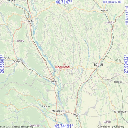
Negulești GPS coordinates[2]
46° 13' 49.656" North, 27° 17' 28.284" East
| Map corner | latitude | longitude |
|---|---|---|
| Upper-left | 46.7147°, | 26.58807° |
| Center: | 46.23046°, | 27.29119° |
| Lower-right: | 45.74191°, | 27.99432° |
| Map W x H: | 108.2×108.2 km | = 67.2×67.2mi |
| max Lat: | 48.23793° ⇑39.7% North |
| Negulești: | 46.23046° |
| min Lat: | ⇓60.3% South 43.65638° |
| min Long | Negulești | max Long |
| 20.31667° | 27.29119° | 29.65403° |
| W 88.2%⇐ | ⇒11.8% E |
Elevation
Elevation of Negulești is 144 m = 472 ft, and this is 110.9 m = 364 ft below average elevation for this country.
| Max E: |
1278 m = 4193 ft | 65.7% |
| Avg. | 254.9 m = 836 ft | |
| Negulești | 144 m = 472 ft | |
Min E: |
-2 m = -7 ft | 34.3% |
See also: Romania elevation on elevation.city.
Geographical zone
Negulești is located in North temperate zone (between Tropic of Cancer and the Arctic Circle). Distance of this North polar circle is 2260.8 km =1404.8 mi to North.| Distance of | km | miles | from Negulești |
|---|---|---|---|
| North Pole | 4866.7 | 3024 | to North |
| Arctic Circle | 2260.8 | 1404.8 | to North |
| Tropic Cancer | 2534.4 | 1574.8 | to South |
| Equator | 5140.3 | 3194 | to South |


Nearby cities:
15 places around Negulești: (largest is in red/bold)
• Bogheşti
11 km =6.8 mi,  130°
130°
• Buda
11 km =6.8 mi,  175°
175°
• Corbasca
11.2 km =7 mi,  301°
301°
• Corbiţa
9 km =5.6 mi, 175°
• Cornii de Sus
8.5 km =5.3 mi,  260°
260°
• Căuia
5.8 km =3.6 mi,  353°
353°
• Dealu Morii
10.6 km =6.6 mi,  335°
335°
• Frumușelu
7.1 km =4.4 mi,  41°
41°
• Glăvăneşti
7.4 km =4.6 mi,  72°
72°
• Huruiești
5.1 km =3.2 mi,  321°
321°
• Lespezi
8.7 km =5.4 mi,  206°
206°
• Podu Turcului
7.9 km =4.9 mi,  115°
115°
• Sârbi
3.6 km =2.2 mi,  89°
89°
• Tătărăști
7.2 km =4.5 mi, 257°
• Țepoaia
10.6 km =6.6 mi,  31°
31°
Sources, notices
• [Note1] Compared only with cities in Romania existing in our database
• [Src1] Map data: © OpenStreetMap contributors (CC-BY-SA)
• [Src2] Other city data from geonames.org with taken over terms of usage.
• [Src3] Geographical zone / Annual Mean Temperature by Robert A. Rohde @ Wikipedia
