Ghimeş-Făget geodata
Ghimeş-Făget (Bacău) is a seat of a second-order administrative division; located in Romania in Europe/Bucharest (GMT+3) time zone. With population of 5,248 people, there are 710 cities with bigger population in this country. Compared to other cities in Romania, 69% of cities are located further ↓South; 64.3% of cities are located further ←West and 98.4% of cities have lower elevation than Ghimeş-Făget. Note1


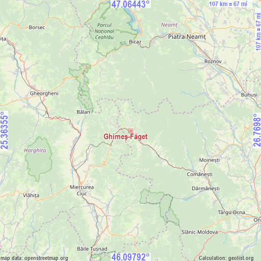
Ghimeş-Făget GPS coordinates[2]
46° 34' 59.988" North, 26° 4' 0.012" East
| Map corner | latitude | longitude |
|---|---|---|
| Upper-left | 47.06443°, | 25.36355° |
| Center: | 46.58333°, | 26.06667° |
| Lower-right: | 46.09792°, | 26.7698° |
| Map W x H: | 107.5×107.5 km | = 66.8×66.8mi |
| max Lat: | 48.23793° ⇑31% North |
| Ghimeş-Făget: | 46.58333° |
| min Lat: | ⇓69% South 43.65638° |
| min Long | Ghimeş-Făget | max Long |
| 20.31667° | 26.06667° | 29.65403° |
| W 64.3%⇐ | ⇒35.7% E |
Elevation
Elevation of Ghimeş-Făget is 804 m = 2638 ft, and this is 549.1 m = 1802 ft above average elevation for this country.
| Max E: |
1278 m = 4193 ft | 1.6% |
| Ghimeş-Făget | 804 m 2638 ft | |
| Avg. | 254.9 m = 836 ft | |
Min E: |
-2 m = -7 ft | 98.4% |
See also: Romania elevation on elevation.city.
Geographical zone
Ghimeş-Făget is located in North temperate zone (between Tropic of Cancer and the Arctic Circle). Distance of this North polar circle is 2221.6 km =1380.4 mi to North.| Distance of | km | miles | from Ghimeş-Făget |
|---|---|---|---|
| North Pole | 4827.5 | 2999.7 | to North |
| Arctic Circle | 2221.6 | 1380.4 | to North |
| Tropic Cancer | 2573.7 | 1599.2 | to South |
| Equator | 5179.6 | 3218.5 | to South |


Nearby cities:
15 places around Ghimeş-Făget: (largest is in red/bold)
• Bolovăniș
3.8 km =2.4 mi,  343°
343°
• Brusturoasa
12.6 km =7.8 mi,  126°
126°
• Camenca
12.6 km =7.8 mi, 126°
• Ciugheș
7.9 km =4.9 mi,  149°
149°
• Cotumba
13.5 km =8.4 mi,  135°
135°
• Făget
1.2 km =0.7 mi,  301°
301°
• Ghimeș
2.4 km =1.5 mi, 134°
• Lunca de Jos
6.6 km =4.1 mi,  253°
253°
• Lunca de Sus
9.5 km =5.9 mi,  233°
233°
• Palanca
6.7 km =4.2 mi, 145°
• Popoiu
6 km =3.7 mi, 139°
• Păltiniș-Ciuc
8.7 km =5.4 mi,  239°
239°
• Tărhăuși
1.8 km =1.1 mi,  62°
62°
• Valea Rece
9.3 km =5.8 mi, 296°
• Valea Ugra
9.4 km =5.8 mi, 226°
Sources, notices
• [Note1] Compared only with cities in Romania existing in our database
• [Src1] Map data: © OpenStreetMap contributors (CC-BY-SA)
• [Src2] Other city data from geonames.org with taken over terms of usage.
• [Src3] Geographical zone / Annual Mean Temperature by Robert A. Rohde @ Wikipedia
