Gheboieni geodata
Gheboieni (Dâmboviţa) is a populated place; located in Romania in Europe/Bucharest (GMT+3) time zone. With population of 1,597 people, there are 3053 cities with bigger population in this country. Compared to other cities in Romania, 70.1% of cities are located further ↑North; 51.4% of cities are located further ←West and 77.4% of cities have lower elevation than Gheboieni. Note1


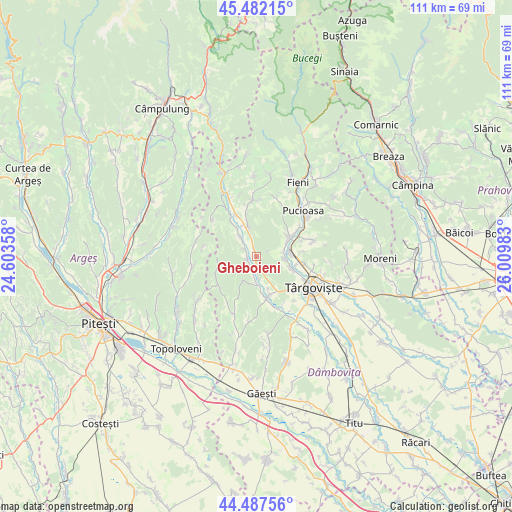
Gheboieni GPS coordinates[2]
44° 59' 13.236" North, 25° 18' 24.12" East
| Map corner | latitude | longitude |
|---|---|---|
| Upper-left | 45.48215°, | 24.60358° |
| Center: | 44.98701°, | 25.3067° |
| Lower-right: | 44.48756°, | 26.00983° |
| Map W x H: | 110.6×110.6 km | = 68.7×68.7mi |
| max Lat: | 48.23793° ⇑70.1% North |
| Gheboieni: | 44.98701° |
| min Lat: | ⇓29.9% South 43.65638° |
| min Long | Gheboieni | max Long |
| 20.31667° | 25.3067° | 29.65403° |
| W 51.4%⇐ | ⇒48.6% E |
Elevation
Elevation of Gheboieni is 371 m = 1217 ft, and this is 116.1 m = 381 ft above average elevation for this country.
| Max E: |
1278 m = 4193 ft | 22.6% |
| Gheboieni | 371 m 1217 ft | |
| Avg. | 254.9 m = 836 ft | |
Min E: |
-2 m = -7 ft | 77.4% |
See also: Romania elevation on elevation.city.
Geographical zone
Gheboieni is located in North temperate zone (between Tropic of Cancer and the Arctic Circle). Distance of this Northern Tropic circle is 2396.2 km =1488.9 mi to South.| Distance of | km | miles | from Gheboieni |
|---|---|---|---|
| North Pole | 5005 | 3110 | to North |
| Arctic Circle | 2399.1 | 1490.7 | to North |
| Tropic Cancer | 2396.2 | 1488.9 | to South |
| Equator | 5002.1 | 3108.2 | to South |


Nearby cities:
15 places around Gheboieni: (largest is in red/bold)
• Căprioru
2.1 km =1.3 mi,  255°
255°
• Decindeni
8.4 km =5.2 mi,  169°
169°
• Doiceşti
7.3 km =4.5 mi,  93°
93°
• Dragomireşti
8.1 km =5 mi, 165°
• Drăgăești Ungureni
4.6 km =2.9 mi,  176°
176°
• Gura Vulcanei
8.2 km =5.1 mi,  59°
59°
• Izvoarele
6 km =3.7 mi,  328°
328°
• Măneşti
2.9 km =1.8 mi,  219°
219°
• Priboiu
6.1 km =3.8 mi,  321°
321°
• Suduleni
7.3 km =4.5 mi,  344°
344°
• Teiș
8 km =5 mi,  109°
109°
• Toculești
8.5 km =5.3 mi, 55°
• Tătărani
3.5 km =2.2 mi,  294°
294°
• Vulcana-Pandele
7.5 km =4.7 mi, 64°
• Şotânga
4.7 km =2.9 mi, 94°
Sources, notices
• [Note1] Compared only with cities in Romania existing in our database
• [Src1] Map data: © OpenStreetMap contributors (CC-BY-SA)
• [Src2] Other city data from geonames.org with taken over terms of usage.
• [Src3] Geographical zone / Annual Mean Temperature by Robert A. Rohde @ Wikipedia
