Geoagiu-Băi geodata
Geoagiu-Băi (Hunedoara) is a populated place; located in Romania in Europe/Bucharest (GMT+3) time zone. With population of 627 people, there are 6031 cities with bigger population in this country. Compared to other cities in Romania, 53.8% of cities are located further ↓South; 82.1% of cities are located further →East and 72.3% of cities have lower elevation than Geoagiu-Băi. Note1


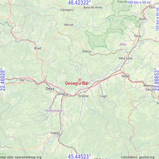
Geoagiu-Băi GPS coordinates[2]
45° 56' 10.968" North, 23° 9' 48.24" East
| Map corner | latitude | longitude |
|---|---|---|
| Upper-left | 46.42322°, | 22.46028° |
| Center: | 45.93638°, | 23.1634° |
| Lower-right: | 45.44523°, | 23.86653° |
| Map W x H: | 108.7×108.7 km | = 67.5×67.5mi |
| max Lat: | 48.23793° ⇑46.2% North |
| Geoagiu-Băi: | 45.93638° |
| min Lat: | ⇓53.8% South 43.65638° |
| min Long | Geoagiu-Băi | max Long |
| 20.31667° | 23.1634° | 29.65403° |
| W 17.9%⇐ | ⇒82.1% E |
Elevation
Elevation of Geoagiu-Băi is 336 m = 1102 ft, and this is 81.1 m = 266 ft above average elevation for this country.
| Max E: |
1278 m = 4193 ft | 27.7% |
| Geoagiu-Băi | 336 m 1102 ft | |
| Avg. | 254.9 m = 836 ft | |
Min E: |
-2 m = -7 ft | 72.3% |
See also: Romania elevation on elevation.city.
Geographical zone
Geoagiu-Băi is located in North temperate zone (between Tropic of Cancer and the Arctic Circle). Distance of this North polar circle is 2293.5 km =1425.1 mi to North.| Distance of | km | miles | from Geoagiu-Băi |
|---|---|---|---|
| North Pole | 4899.4 | 3044.3 | to North |
| Arctic Circle | 2293.5 | 1425.1 | to North |
| Tropic Cancer | 2501.7 | 1554.5 | to South |
| Equator | 5107.6 | 3173.7 | to South |


Nearby cities:
15 places around Geoagiu-Băi: (largest is in red/bold)
• Aurel Vlaicu
9.3 km =5.8 mi,  108°
108°
• Balşa
11.4 km =7.1 mi,  341°
341°
• Banpotoc
12.6 km =7.8 mi,  249°
249°
• Bobâlna
7.2 km =4.5 mi,  200°
200°
• Ceru-Băcăinţi
8.5 km =5.3 mi,  52°
52°
• Căstău
14 km =8.7 mi,  164°
164°
• Geoagiu
3.6 km =2.2 mi,  127°
127°
• Mărtineşti
13.5 km =8.4 mi,  189°
189°
• Orăştie
11.8 km =7.3 mi,  166°
166°
• Pricaz
8.6 km =5.3 mi,  175°
175°
• Rapoltu Mare
10.8 km =6.7 mi,  223°
223°
• Romos
14.7 km =9.1 mi,  140°
140°
• Turdaş
10.3 km =6.4 mi, 200°
• Vaidei
13.1 km =8.1 mi, 125°
• Şibot
13.2 km =8.2 mi,  83°
83°
Sources, notices
• [Note1] Compared only with cities in Romania existing in our database
• [Src1] Map data: © OpenStreetMap contributors (CC-BY-SA)
• [Src2] Other city data from geonames.org with taken over terms of usage.
• [Src3] Geographical zone / Annual Mean Temperature by Robert A. Rohde @ Wikipedia
