Orăştie geodata
Orăştie (Hunedoara) is a seat of a second-order administrative division; located in Romania in Europe/Bucharest (GMT+3) time zone. With population of 20,763 people, there are 97 cities with bigger population in this country. Compared to other cities in Romania, 51% of cities are located further ↓South; 81.5% of cities are located further →East and 52.5% of cities have lower elevation than Orăştie. Note1


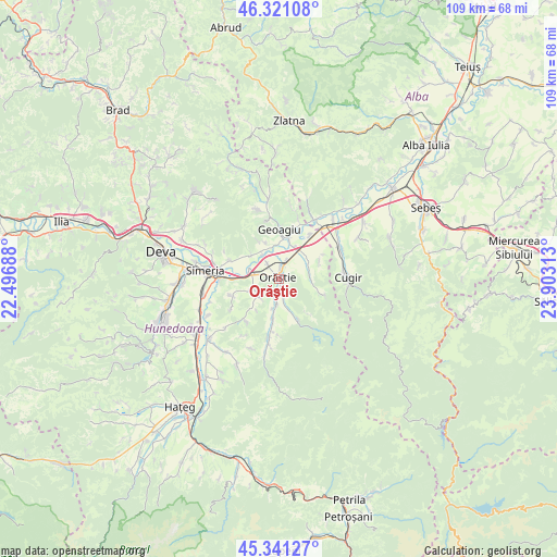
Orăştie GPS coordinates[2]
45° 49' 59.988" North, 23° 12' 0" East
| Map corner | latitude | longitude |
|---|---|---|
| Upper-left | 46.32108°, | 22.49688° |
| Center: | 45.83333°, | 23.2° |
| Lower-right: | 45.34127°, | 23.90313° |
| Map W x H: | 108.9×108.9 km | = 67.7×67.7mi |
| max Lat: | 48.23793° ⇑49% North |
| Orăştie: | 45.83333° |
| min Lat: | ⇓51% South 43.65638° |
| min Long | Orăştie | max Long |
| 20.31667° | 23.2° | 29.65403° |
| W 18.5%⇐ | ⇒81.5% E |
Elevation
Elevation of Orăştie is 224 m = 735 ft, and this is 30.9 m = 101 ft below average elevation for this country.
| Max E: |
1278 m = 4193 ft | 47.5% |
| Avg. | 254.9 m = 836 ft | |
| Orăştie | 224 m = 735 ft | |
Min E: |
-2 m = -7 ft | 52.5% |
See also: Romania elevation on elevation.city.
Geographical zone
Orăştie is located in North temperate zone (between Tropic of Cancer and the Arctic Circle). Distance of this North polar circle is 2305 km =1432.3 mi to North.| Distance of | km | miles | from Orăştie |
|---|---|---|---|
| North Pole | 4910.9 | 3051.5 | to North |
| Arctic Circle | 2305 | 1432.3 | to North |
| Tropic Cancer | 2490.3 | 1547.4 | to South |
| Equator | 5096.2 | 3166.6 | to South |


Nearby cities:
15 places around Orăştie: (largest is in red/bold)
• Aurel Vlaicu
10.5 km =6.5 mi,  35°
35°
• Beriu
5.7 km =3.5 mi,  193°
193°
• Bobâlna
7.2 km =4.5 mi,  311°
311°
• Căstău
2.3 km =1.4 mi,  156°
156°
• Geoagiu
9.3 km =5.8 mi,  0°
0°
• Geoagiu-Băi
11.8 km =7.3 mi,  346°
346°
• Mărtineşti
5.5 km =3.4 mi,  250°
250°
• Orăştioara de Sus
11.4 km =7.1 mi, 193°
• Pricaz
3.6 km =2.2 mi,  323°
323°
• Rapoltu Mare
11 km =6.8 mi,  289°
289°
• Romos
6.5 km =4 mi,  90°
90°
• Romoșel
9.3 km =5.8 mi,  109°
109°
• Sibișel
10 km =6.2 mi, 157°
• Turdaş
6.7 km =4.2 mi, 286°
• Vaidei
8.7 km =5.4 mi,  64°
64°
Sources, notices
• [Note1] Compared only with cities in Romania existing in our database
• [Src1] Map data: © OpenStreetMap contributors (CC-BY-SA)
• [Src2] Other city data from geonames.org with taken over terms of usage.
• [Src3] Geographical zone / Annual Mean Temperature by Robert A. Rohde @ Wikipedia
