Pricaz geodata
Pricaz (Hunedoara) is a populated place; located in Romania in Europe/Bucharest (GMT+3) time zone. With population of 1,141 people, there are 3875 cities with bigger population in this country. Compared to other cities in Romania, 51.8% of cities are located further ↓South; 82% of cities are located further →East and 50.8% of cities have higher elevation than Pricaz. Note1


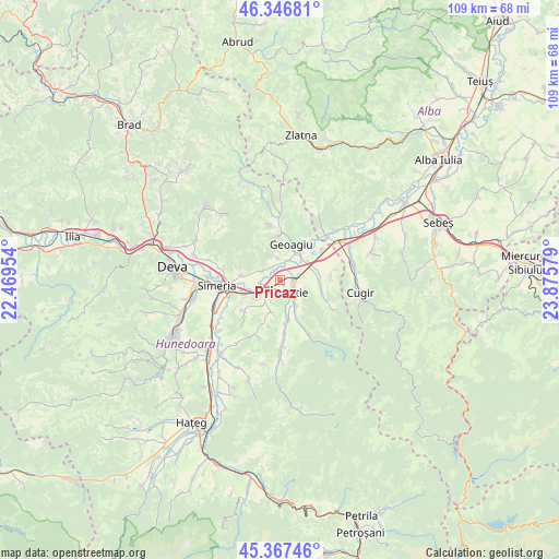
Pricaz GPS coordinates[2]
45° 51' 33.444" North, 23° 10' 21.576" East
| Map corner | latitude | longitude |
|---|---|---|
| Upper-left | 46.34681°, | 22.46954° |
| Center: | 45.85929°, | 23.17266° |
| Lower-right: | 45.36746°, | 23.87579° |
| Map W x H: | 108.9×108.9 km | = 67.7×67.7mi |
| max Lat: | 48.23793° ⇑48.2% North |
| Pricaz: | 45.85929° |
| min Lat: | ⇓51.8% South 43.65638° |
| min Long | Pricaz | max Long |
| 20.31667° | 23.17266° | 29.65403° |
| W 18%⇐ | ⇒82% E |
Elevation
Elevation of Pricaz is 207 m = 679 ft, and this is 47.9 m = 157 ft below average elevation for this country.
| Max E: |
1278 m = 4193 ft | 50.8% |
| Avg. | 254.9 m = 836 ft | |
| Pricaz | 207 m = 679 ft | |
Min E: |
-2 m = -7 ft | 49.2% |
See also: Romania elevation on elevation.city.
Geographical zone
Pricaz is located in North temperate zone (between Tropic of Cancer and the Arctic Circle). Distance of this North polar circle is 2302.1 km =1430.5 mi to North.| Distance of | km | miles | from Pricaz |
|---|---|---|---|
| North Pole | 4908 | 3049.7 | to North |
| Arctic Circle | 2302.1 | 1430.5 | to North |
| Tropic Cancer | 2493.2 | 1549.2 | to South |
| Equator | 5099.1 | 3168.4 | to South |


Nearby cities:
15 places around Pricaz: (largest is in red/bold)
• Aurel Vlaicu
9.9 km =6.2 mi,  55°
55°
• Beriu
8.5 km =5.3 mi,  174°
174°
• Bobâlna
3.8 km =2.4 mi,  299°
299°
• Căstău
5.8 km =3.6 mi,  148°
148°
• Geoagiu
6.7 km =4.2 mi,  18°
18°
• Geoagiu-Băi
8.6 km =5.3 mi,  355°
355°
• Mărtineşti
5.6 km =3.5 mi,  212°
212°
• Orăştie
3.6 km =2.2 mi,  143°
143°
• Rapoltu Mare
8.2 km =5.1 mi,  275°
275°
• Romos
9 km =5.6 mi,  108°
108°
• Romoșel
12.4 km =7.7 mi,  118°
118°
• Simeria
12.1 km =7.5 mi,  265°
265°
• Turdaş
4.5 km =2.8 mi,  256°
256°
• Tâmpa
12.8 km =8 mi,  253°
253°
• Vaidei
10 km =6.2 mi,  84°
84°
Sources, notices
• [Note1] Compared only with cities in Romania existing in our database
• [Src1] Map data: © OpenStreetMap contributors (CC-BY-SA)
• [Src2] Other city data from geonames.org with taken over terms of usage.
• [Src3] Geographical zone / Annual Mean Temperature by Robert A. Rohde @ Wikipedia
