Genuneni geodata
Genuneni (Vâlcea) is a populated place; located in Romania in Europe/Bucharest (GMT+3) time zone. With population of 560 people, there are 6501 cities with bigger population in this country. Compared to other cities in Romania, 68.6% of cities are located further ↑North; 67.5% of cities are located further →East and 66.7% of cities have lower elevation than Genuneni. Note1


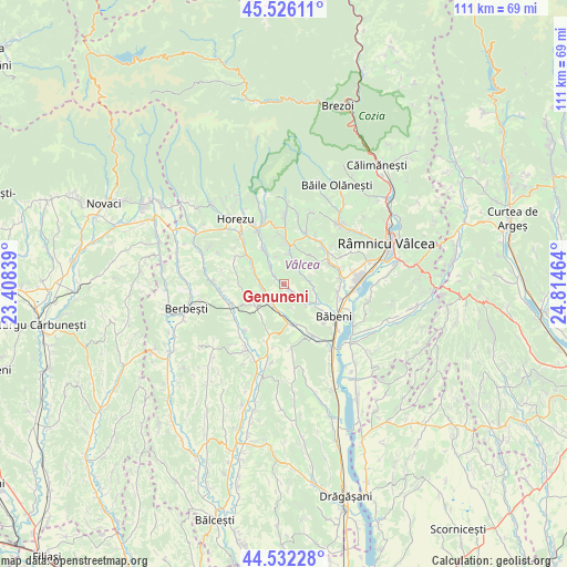
Genuneni GPS coordinates[2]
45° 1' 52.86" North, 24° 6' 41.436" East
| Map corner | latitude | longitude |
|---|---|---|
| Upper-left | 45.52611°, | 23.40839° |
| Center: | 45.03135°, | 24.11151° |
| Lower-right: | 44.53228°, | 24.81464° |
| Map W x H: | 110.5×110.5 km | = 68.7×68.7mi |
| max Lat: | 48.23793° ⇑68.6% North |
| Genuneni: | 45.03135° |
| min Lat: | ⇓31.4% South 43.65638° |
| min Long | Genuneni | max Long |
| 20.31667° | 24.11151° | 29.65403° |
| W 32.5%⇐ | ⇒67.5% E |
Elevation
Elevation of Genuneni is 300 m = 984 ft, and this is 45.1 m = 148 ft above average elevation for this country.
| Max E: |
1278 m = 4193 ft | 33.3% |
| Genuneni | 300 m 984 ft | |
| Avg. | 254.9 m = 836 ft | |
Min E: |
-2 m = -7 ft | 66.7% |
See also: Romania elevation on elevation.city.
Geographical zone
Genuneni is located in North temperate zone (between Tropic of Cancer and the Arctic Circle). Distance of this North polar circle is 2394.2 km =1487.7 mi to North.| Distance of | km | miles | from Genuneni |
|---|---|---|---|
| North Pole | 5000 | 3106.9 | to North |
| Arctic Circle | 2394.2 | 1487.7 | to North |
| Tropic Cancer | 2401.1 | 1492 | to South |
| Equator | 5007 | 3111.2 | to South |


Nearby cities:
15 places around Genuneni: (largest is in red/bold)
• Armășești
7.8 km =4.8 mi,  258°
258°
• Băltățeni
6.9 km =4.3 mi,  329°
329°
• Coșani
6.8 km =4.2 mi,  112°
112°
• Dezrobiți
6 km =3.7 mi,  94°
94°
• Dăeşti
7.4 km =4.6 mi,  166°
166°
• Foleştii de Jos
4.2 km =2.6 mi,  322°
322°
• Frânceşti
7.1 km =4.4 mi,  120°
120°
• Modoia
7.4 km =4.6 mi,  214°
214°
• Mănăilești
1.3 km =0.8 mi,  126°
126°
• Oteşani
7.3 km =4.5 mi,  302°
302°
• Pietrari
7.8 km =4.8 mi,  12°
12°
• Popeşti
5.4 km =3.4 mi,  189°
189°
• Prajila
7.3 km =4.5 mi,  38°
38°
• Păuşeşti
5 km =3.1 mi,  21°
21°
• Urși
4.5 km =2.8 mi,  203°
203°
Sources, notices
• [Note1] Compared only with cities in Romania existing in our database
• [Src1] Map data: © OpenStreetMap contributors (CC-BY-SA)
• [Src2] Other city data from geonames.org with taken over terms of usage.
• [Src3] Geographical zone / Annual Mean Temperature by Robert A. Rohde @ Wikipedia
