Gemenele geodata
Gemenele (Brăila) is a seat of a second-order administrative division; located in Romania in Europe/Bucharest (GMT+3) time zone. With population of 1,899 people, there are 2705 cities with bigger population in this country. Compared to other cities in Romania, 59.4% of cities are located further ↑North; 92.3% of cities are located further ←West and 98.7% of cities have higher elevation than Gemenele. Note1


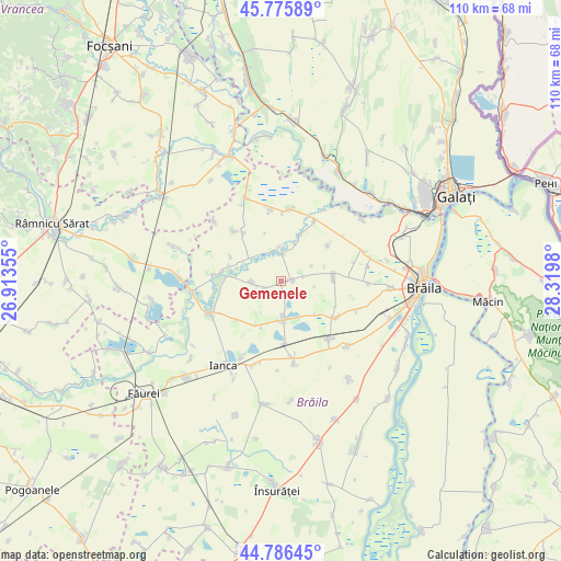
Gemenele GPS coordinates[2]
45° 16' 59.988" North, 27° 37' 0.012" East
| Map corner | latitude | longitude |
|---|---|---|
| Upper-left | 45.77589°, | 26.91355° |
| Center: | 45.28333°, | 27.61667° |
| Lower-right: | 44.78645°, | 28.3198° |
| Map W x H: | 110×110 km | = 68.4×68.4mi |
| max Lat: | 48.23793° ⇑59.4% North |
| Gemenele: | 45.28333° |
| min Lat: | ⇓40.6% South 43.65638° |
| min Long | Gemenele | max Long |
| 20.31667° | 27.61667° | 29.65403° |
| W 92.3%⇐ | ⇒7.7% E |
Elevation
Elevation of Gemenele is 13 m = 43 ft, and this is 241.9 m = 794 ft below average elevation for this country.
| Max E: |
1278 m = 4193 ft | 98.7% |
| Avg. | 254.9 m = 836 ft | |
| Gemenele | 13 m = 43 ft | |
Min E: |
-2 m = -7 ft | 1.3% |
See also: Romania elevation on elevation.city.
Geographical zone
Gemenele is located in North temperate zone (between Tropic of Cancer and the Arctic Circle). Distance of this North polar circle is 2366.1 km =1470.2 mi to North.| Distance of | km | miles | from Gemenele |
|---|---|---|---|
| North Pole | 4972 | 3089.5 | to North |
| Arctic Circle | 2366.1 | 1470.2 | to North |
| Tropic Cancer | 2429.1 | 1509.4 | to South |
| Equator | 5035 | 3128.6 | to South |


Nearby cities:
15 places around Gemenele: (largest is in red/bold)
• Corbu Nou
14.2 km =8.8 mi,  352°
352°
• Latinu
13.6 km =8.5 mi,  28°
28°
• Movila Miresii
7.5 km =4.7 mi,  189°
189°
• Măxineni
13 km =8.1 mi,  5°
5°
• Racoviţa
13.2 km =8.2 mi,  278°
278°
• Romanu
9.1 km =5.7 mi,  90°
90°
• Râmnicelu
6.5 km =4 mi,  270°
270°
• Salcia Tudor
12.1 km =7.5 mi,  319°
319°
• Scorţaru Nou
3.9 km =2.4 mi,  340°
340°
• Scorțaru Vechi
13 km =8.1 mi,  123°
123°
• Traian
14.4 km =8.9 mi,  140°
140°
• Tudor Vladimirescu
16.2 km =10.1 mi, 117°
• Urleasca
16.5 km =10.3 mi,  171°
171°
• Şuţeşti
16.2 km =10.1 mi,  242°
242°
• Țepeș Vodă
12.5 km =7.8 mi,  178°
178°
Sources, notices
• [Note1] Compared only with cities in Romania existing in our database
• [Src1] Map data: © OpenStreetMap contributors (CC-BY-SA)
• [Src2] Other city data from geonames.org with taken over terms of usage.
• [Src3] Geographical zone / Annual Mean Temperature by Robert A. Rohde @ Wikipedia
