Galoșpetreu geodata
Galoșpetreu (Bihor) is a populated place; located in Romania in Europe/Bucharest (GMT+3) time zone. With population of 1,025 people, there are 4204 cities with bigger population in this country. Compared to other cities in Romania, 90.7% of cities are located further ↓South; 92.6% of cities are located further →East and 74.5% of cities have higher elevation than Galoșpetreu. Note1


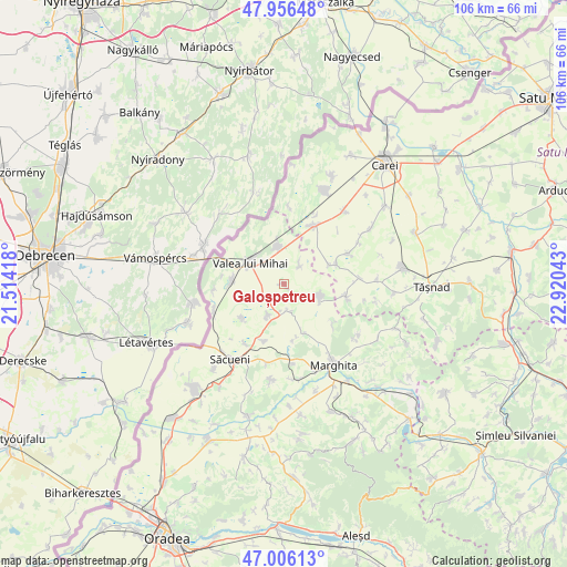
Galoșpetreu GPS coordinates[2]
47° 29' 0.42" North, 22° 13' 2.28" East
| Map corner | latitude | longitude |
|---|---|---|
| Upper-left | 47.95648°, | 21.51418° |
| Center: | 47.48345°, | 22.2173° |
| Lower-right: | 47.00613°, | 22.92043° |
| Map W x H: | 105.7×105.7 km | = 65.7×65.7mi |
| max Lat: | 48.23793° ⇑9.3% North |
| Galoșpetreu: | 47.48345° |
| min Lat: | ⇓90.7% South 43.65638° |
| min Long | Galoșpetreu | max Long |
| 20.31667° | 22.2173° | 29.65403° |
| W 7.4%⇐ | ⇒92.6% E |
Elevation
Elevation of Galoșpetreu is 112 m = 367 ft, and this is 142.9 m = 469 ft below average elevation for this country.
| Max E: |
1278 m = 4193 ft | 74.5% |
| Avg. | 254.9 m = 836 ft | |
| Galoșpetreu | 112 m = 367 ft | |
Min E: |
-2 m = -7 ft | 25.5% |
See also: Romania elevation on elevation.city.
Geographical zone
Galoșpetreu is located in North temperate zone (between Tropic of Cancer and the Arctic Circle). Distance of this North polar circle is 2121.5 km =1318.2 mi to North.| Distance of | km | miles | from Galoșpetreu |
|---|---|---|---|
| North Pole | 4727.4 | 2937.5 | to North |
| Arctic Circle | 2121.5 | 1318.2 | to North |
| Tropic Cancer | 2673.7 | 1661.4 | to South |
| Equator | 5279.7 | 3280.7 | to South |


Nearby cities:
15 places around Galoșpetreu: (largest is in red/bold)
• Adoni
6.5 km =4 mi,  208°
208°
• Albiș
10.6 km =6.6 mi,  168°
168°
• Andrid
10.6 km =6.6 mi,  69°
69°
• Buduslău
10 km =6.2 mi,  158°
158°
• Cheșereu
9.9 km =6.2 mi,  231°
231°
• Cheț
11.6 km =7.2 mi,  127°
127°
• Curtuișeni
7.1 km =4.4 mi,  351°
351°
• Otomani
5.3 km =3.3 mi, 163°
• Pir
11.4 km =7.1 mi,  99°
99°
• Sălacea
7.7 km =4.8 mi, 104°
• Tarcea
4.5 km =2.8 mi, 214°
• Târgușor
11.8 km =7.3 mi,  198°
198°
• Valea lui Mihai
6.3 km =3.9 mi,  306°
306°
• Vășad
4.9 km =3 mi,  37°
37°
• Şimian
8.8 km =5.5 mi,  269°
269°
Sources, notices
• [Note1] Compared only with cities in Romania existing in our database
• [Src1] Map data: © OpenStreetMap contributors (CC-BY-SA)
• [Src2] Other city data from geonames.org with taken over terms of usage.
• [Src3] Geographical zone / Annual Mean Temperature by Robert A. Rohde @ Wikipedia
