Cheț geodata
Cheț (Bihor) is a populated place; located in Romania in Europe/Bucharest (GMT+3) time zone. With population of 1,110 people, there are 3959 cities with bigger population in this country. Compared to other cities in Romania, 89.3% of cities are located further ↓South; 91.2% of cities are located further →East and 58.9% of cities have higher elevation than Cheț. Note1


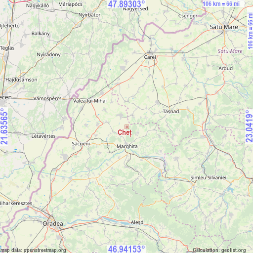
Cheț GPS coordinates[2]
47° 25' 9.948" North, 22° 20' 19.572" East
| Map corner | latitude | longitude |
|---|---|---|
| Upper-left | 47.89303°, | 21.63565° |
| Center: | 47.41943°, | 22.33877° |
| Lower-right: | 46.94153°, | 23.0419° |
| Map W x H: | 105.8×105.8 km | = 65.7×65.7mi |
| max Lat: | 48.23793° ⇑10.7% North |
| Cheț: | 47.41943° |
| min Lat: | ⇓89.3% South 43.65638° |
| min Long | Cheț | max Long |
| 20.31667° | 22.33877° | 29.65403° |
| W 8.8%⇐ | ⇒91.2% E |
Elevation
Elevation of Cheț is 170 m = 558 ft, and this is 84.9 m = 279 ft below average elevation for this country.
| Max E: |
1278 m = 4193 ft | 58.9% |
| Avg. | 254.9 m = 836 ft | |
| Cheț | 170 m = 558 ft | |
Min E: |
-2 m = -7 ft | 41.1% |
See also: Romania elevation on elevation.city.
Geographical zone
Cheț is located in North temperate zone (between Tropic of Cancer and the Arctic Circle). Distance of this North polar circle is 2128.6 km =1322.7 mi to North.| Distance of | km | miles | from Cheț |
|---|---|---|---|
| North Pole | 4734.5 | 2941.9 | to North |
| Arctic Circle | 2128.6 | 1322.7 | to North |
| Tropic Cancer | 2666.6 | 1656.9 | to South |
| Equator | 5272.5 | 3276.2 | to South |


Nearby cities:
15 places around Cheț: (largest is in red/bold)
• Abram
11.9 km =7.4 mi,  163°
163°
• Albiș
7.7 km =4.8 mi,  245°
245°
• Andrid
10.8 km =6.7 mi,  4°
4°
• Becheni
9.1 km =5.7 mi,  66°
66°
• Buduslău
5.8 km =3.6 mi, 248°
• Chereușa
11.7 km =7.3 mi,  46°
46°
• Galoșpetreu
11.6 km =7.2 mi,  307°
307°
• Ghenetea
5.6 km =3.5 mi,  127°
127°
• Marghita
7.7 km =4.8 mi,  183°
183°
• Otomani
7.9 km =4.9 mi,  284°
284°
• Petreu
9.7 km =6 mi,  199°
199°
• Pir
5.7 km =3.5 mi,  21°
21°
• Sălacea
5.5 km =3.4 mi,  342°
342°
• Săuca
12.1 km =7.5 mi,  64°
64°
• Viişoara
9.3 km =5.8 mi,  115°
115°
Sources, notices
• [Note1] Compared only with cities in Romania existing in our database
• [Src1] Map data: © OpenStreetMap contributors (CC-BY-SA)
• [Src2] Other city data from geonames.org with taken over terms of usage.
• [Src3] Geographical zone / Annual Mean Temperature by Robert A. Rohde @ Wikipedia
