Albiș geodata
Albiș (Bihor) is a populated place; located in Romania in Europe/Bucharest (GMT+3) time zone. With population of 1,059 people, there are 4094 cities with bigger population in this country. Compared to other cities in Romania, 88.7% of cities are located further ↓South; 92.4% of cities are located further →East and 68% of cities have higher elevation than Albiș. Note1


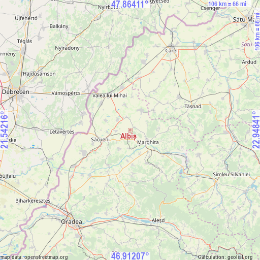
Albiș GPS coordinates[2]
47° 23' 24.864" North, 22° 14' 43.008" East
| Map corner | latitude | longitude |
|---|---|---|
| Upper-left | 47.86411°, | 21.54216° |
| Center: | 47.39024°, | 22.24528° |
| Lower-right: | 46.91207°, | 22.94841° |
| Map W x H: | 105.9×105.9 km | = 65.8×65.8mi |
| max Lat: | 48.23793° ⇑11.3% North |
| Albiș: | 47.39024° |
| min Lat: | ⇓88.7% South 43.65638° |
| min Long | Albiș | max Long |
| 20.31667° | 22.24528° | 29.65403° |
| W 7.6%⇐ | ⇒92.4% E |
Elevation
Elevation of Albiș is 135 m = 443 ft, and this is 119.9 m = 393 ft below average elevation for this country.
| Max E: |
1278 m = 4193 ft | 68% |
| Avg. | 254.9 m = 836 ft | |
| Albiș | 135 m = 443 ft | |
Min E: |
-2 m = -7 ft | 32% |
See also: Romania elevation on elevation.city.
Geographical zone
Albiș is located in North temperate zone (between Tropic of Cancer and the Arctic Circle). Distance of this North polar circle is 2131.9 km =1324.7 mi to North.| Distance of | km | miles | from Albiș |
|---|---|---|---|
| North Pole | 4737.8 | 2943.9 | to North |
| Arctic Circle | 2131.9 | 1324.7 | to North |
| Tropic Cancer | 2663.4 | 1655 | to South |
| Equator | 5269.3 | 3274.2 | to South |


Nearby cities:
15 places around Albiș: (largest is in red/bold)
• Abrămuţ
8.2 km =5.1 mi,  177°
177°
• Adoni
7 km =4.3 mi,  311°
311°
• Buduslău
1.9 km =1.2 mi,  56°
56°
• Cherechiu
8.5 km =5.3 mi,  264°
264°
• Cheț
7.7 km =4.8 mi,  65°
65°
• Chiraleu
10.3 km =6.4 mi,  157°
157°
• Cubulcut
8.7 km =5.4 mi,  210°
210°
• Galoșpetreu
10.6 km =6.6 mi,  348°
348°
• Marghita
8 km =5 mi,  124°
124°
• Olosig
6.6 km =4.1 mi,  229°
229°
• Otomani
5.3 km =3.3 mi, 353°
• Petreu
7 km =4.3 mi,  146°
146°
• Sălacea
10.1 km =6.3 mi,  32°
32°
• Tarcea
8.1 km =5 mi,  324°
324°
• Târgușor
6 km =3.7 mi, 262°
Sources, notices
• [Note1] Compared only with cities in Romania existing in our database
• [Src1] Map data: © OpenStreetMap contributors (CC-BY-SA)
• [Src2] Other city data from geonames.org with taken over terms of usage.
• [Src3] Geographical zone / Annual Mean Temperature by Robert A. Rohde @ Wikipedia
