Găiseni geodata
Găiseni (Giurgiu) is a seat of a second-order administrative division; located in Romania in Europe/Bucharest (GMT+3) time zone. With population of 5,455 people, there are 648 cities with bigger population in this country. Compared to other cities in Romania, 84.9% of cities are located further ↑North; 56.8% of cities are located further ←West and 70.6% of cities have higher elevation than Găiseni. Note1


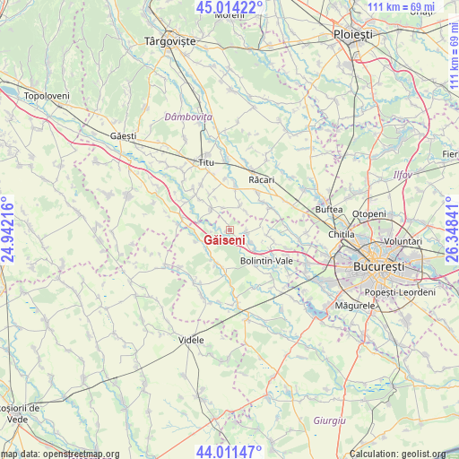
Găiseni GPS coordinates[2]
44° 30' 54" North, 25° 38' 43.008" East
| Map corner | latitude | longitude |
|---|---|---|
| Upper-left | 45.01422°, | 24.94216° |
| Center: | 44.515°, | 25.64528° |
| Lower-right: | 44.01147°, | 26.34841° |
| Map W x H: | 111.5×111.5 km | = 69.3×69.3mi |
| max Lat: | 48.23793° ⇑84.9% North |
| Găiseni: | 44.515° |
| min Lat: | ⇓15.1% South 43.65638° |
| min Long | Găiseni | max Long |
| 20.31667° | 25.64528° | 29.65403° |
| W 56.8%⇐ | ⇒43.2% E |
Elevation
Elevation of Găiseni is 125 m = 410 ft, and this is 129.9 m = 426 ft below average elevation for this country.
| Max E: |
1278 m = 4193 ft | 70.6% |
| Avg. | 254.9 m = 836 ft | |
| Găiseni | 125 m = 410 ft | |
Min E: |
-2 m = -7 ft | 29.4% |
See also: Romania elevation on elevation.city.
Geographical zone
Găiseni is located in North temperate zone (between Tropic of Cancer and the Arctic Circle). Distance of this Northern Tropic circle is 2343.7 km =1456.3 mi to South.| Distance of | km | miles | from Găiseni |
|---|---|---|---|
| North Pole | 5057.5 | 3142.6 | to North |
| Arctic Circle | 2451.6 | 1523.4 | to North |
| Tropic Cancer | 2343.7 | 1456.3 | to South |
| Equator | 4949.6 | 3075.5 | to South |


Nearby cities:
15 places around Găiseni: (largest is in red/bold)
• Cărpenișu
2.3 km =1.4 mi,  336°
336°
• Căscioarele
1.9 km =1.2 mi,  197°
197°
• Drăgăneasca
7.7 km =4.8 mi,  78°
78°
• Florești
4.1 km =2.5 mi,  92°
92°
• Găiseanca
7.9 km =4.9 mi,  215°
215°
• Icoana
8.4 km =5.2 mi,  106°
106°
• Izvoru
8.3 km =5.2 mi,  265°
265°
• Palanca
7.7 km =4.8 mi,  124°
124°
• Poiana
6.5 km =4 mi,  27°
27°
• Poiana lui Stângă
4.7 km =2.9 mi, 265°
• Potlogi
6.3 km =3.9 mi,  308°
308°
• Românești
6.2 km =3.9 mi, 338°
• Stoenești
6.2 km =3.9 mi, 121°
• Suseni
8.1 km =5 mi,  150°
150°
• Vânătorii Mici
7.4 km =4.6 mi,  248°
248°
Sources, notices
• [Note1] Compared only with cities in Romania existing in our database
• [Src1] Map data: © OpenStreetMap contributors (CC-BY-SA)
• [Src2] Other city data from geonames.org with taken over terms of usage.
• [Src3] Geographical zone / Annual Mean Temperature by Robert A. Rohde @ Wikipedia
