Florești geodata
Florești (Giurgiu) is a populated place; located in Romania in Europe/Bucharest (GMT+3) time zone. With population of 4,332 people, there are 1033 cities with bigger population in this country. Compared to other cities in Romania, 84.9% of cities are located further ↑North; 57.5% of cities are located further ←West and 72.3% of cities have higher elevation than Florești. Note1


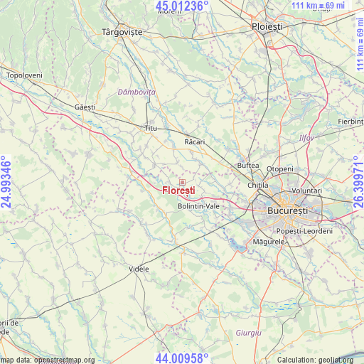
Florești GPS coordinates[2]
44° 30' 47.268" North, 25° 41' 47.688" East
| Map corner | latitude | longitude |
|---|---|---|
| Upper-left | 45.01236°, | 24.99346° |
| Center: | 44.51313°, | 25.69658° |
| Lower-right: | 44.00958°, | 26.39971° |
| Map W x H: | 111.5×111.5 km | = 69.3×69.3mi |
| max Lat: | 48.23793° ⇑84.9% North |
| Florești: | 44.51313° |
| min Lat: | ⇓15.1% South 43.65638° |
| min Long | Florești | max Long |
| 20.31667° | 25.69658° | 29.65403° |
| W 57.5%⇐ | ⇒42.5% E |
Elevation
Elevation of Florești is 119 m = 390 ft, and this is 135.9 m = 446 ft below average elevation for this country.
| Max E: |
1278 m = 4193 ft | 72.3% |
| Avg. | 254.9 m = 836 ft | |
| Florești | 119 m = 390 ft | |
Min E: |
-2 m = -7 ft | 27.7% |
See also: Romania elevation on elevation.city.
Geographical zone
Florești is located in North temperate zone (between Tropic of Cancer and the Arctic Circle). Distance of this Northern Tropic circle is 2343.5 km =1456.2 mi to South.| Distance of | km | miles | from Florești |
|---|---|---|---|
| North Pole | 5057.7 | 3142.7 | to North |
| Arctic Circle | 2451.8 | 1523.5 | to North |
| Tropic Cancer | 2343.5 | 1456.2 | to South |
| Equator | 4949.4 | 3075.4 | to South |


Nearby cities:
15 places around Florești: (largest is in red/bold)
• Brezoaele
8.3 km =5.2 mi,  20°
20°
• Brezoaia
8.5 km =5.3 mi,  55°
55°
• Cărpenișu
5.5 km =3.4 mi,  294°
294°
• Căscioarele
4.9 km =3 mi,  251°
251°
• Drăgăneasca
3.9 km =2.4 mi, 62°
• Găiseni
4.1 km =2.5 mi,  272°
272°
• Icoana
4.5 km =2.8 mi,  119°
119°
• Malu Spart
7.9 km =4.9 mi,  167°
167°
• Palanca
4.8 km =3 mi,  150°
150°
• Poenari
7.6 km =4.7 mi,  128°
128°
• Poiana
6 km =3.7 mi,  349°
349°
• Stoenești
3.3 km =2.1 mi,  158°
158°
• Suseni
6.9 km =4.3 mi,  180°
180°
• Trestieni
5 km =3.1 mi,  101°
101°
• Ulmi
7.3 km =4.5 mi,  113°
113°
Sources, notices
• [Note1] Compared only with cities in Romania existing in our database
• [Src1] Map data: © OpenStreetMap contributors (CC-BY-SA)
• [Src2] Other city data from geonames.org with taken over terms of usage.
• [Src3] Geographical zone / Annual Mean Temperature by Robert A. Rohde @ Wikipedia
