Poiana geodata
Poiana (Dâmboviţa) is a seat of a second-order administrative division; located in Romania in Europe/Bucharest (GMT+3) time zone. With population of 3,930 people, there are 1198 cities with bigger population in this country. Compared to other cities in Romania, 83.8% of cities are located further ↑North; 57.3% of cities are located further ←West and 70.2% of cities have higher elevation than Poiana. Note1


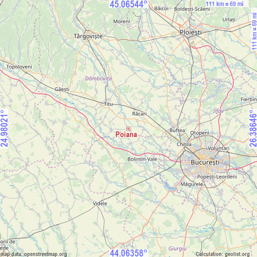
Poiana GPS coordinates[2]
44° 34' 0.012" North, 25° 40' 59.988" East
| Map corner | latitude | longitude |
|---|---|---|
| Upper-left | 45.06544°, | 24.98021° |
| Center: | 44.56667°, | 25.68333° |
| Lower-right: | 44.06358°, | 26.38646° |
| Map W x H: | 111.4×111.4 km | = 69.2×69.2mi |
| max Lat: | 48.23793° ⇑83.8% North |
| Poiana: | 44.56667° |
| min Lat: | ⇓16.2% South 43.65638° |
| min Long | Poiana | max Long |
| 20.31667° | 25.68333° | 29.65403° |
| W 57.3%⇐ | ⇒42.7% E |
Elevation
Elevation of Poiana is 126 m = 413 ft, and this is 128.9 m = 423 ft below average elevation for this country.
| Max E: |
1278 m = 4193 ft | 70.2% |
| Avg. | 254.9 m = 836 ft | |
| Poiana | 126 m = 413 ft | |
Min E: |
-2 m = -7 ft | 29.8% |
See also: Romania elevation on elevation.city.
Geographical zone
Poiana is located in North temperate zone (between Tropic of Cancer and the Arctic Circle). Distance of this Northern Tropic circle is 2349.4 km =1459.8 mi to South.| Distance of | km | miles | from Poiana |
|---|---|---|---|
| North Pole | 5051.7 | 3139 | to North |
| Arctic Circle | 2445.8 | 1519.7 | to North |
| Tropic Cancer | 2349.4 | 1459.8 | to South |
| Equator | 4955.3 | 3079.1 | to South |


Nearby cities:
15 places around Poiana: (largest is in red/bold)
• Brezoaele
4.4 km =2.7 mi,  64°
64°
• Brezoaia
8.1 km =5 mi,  97°
97°
• Cărpenișu
5.3 km =3.3 mi,  226°
226°
• Căscioarele
8.3 km =5.2 mi,  205°
205°
• Drăgăneasca
6.2 km =3.9 mi,  132°
132°
• Florești
6 km =3.7 mi,  169°
169°
• Ghergani
8.3 km =5.2 mi,  22°
22°
• Găiseni
6.5 km =4 mi, 207°
• Lunguleţu
6.2 km =3.9 mi,  334°
334°
• Pitaru
8.3 km =5.2 mi,  288°
288°
• Potlogi
8.1 km =5 mi,  256°
256°
• Românești
5.3 km =3.3 mi,  270°
270°
• Serdanu
7.9 km =4.9 mi, 328°
• Slobozia Moara
4.6 km =2.9 mi,  35°
35°
• Vlăsceni
7 km =4.3 mi, 287°
Sources, notices
• [Note1] Compared only with cities in Romania existing in our database
• [Src1] Map data: © OpenStreetMap contributors (CC-BY-SA)
• [Src2] Other city data from geonames.org with taken over terms of usage.
• [Src3] Geographical zone / Annual Mean Temperature by Robert A. Rohde @ Wikipedia
