Fundu Răcăciuni geodata
Fundu Răcăciuni (Bacău) is a populated place; located in Romania in Europe/Bucharest (GMT+3) time zone. With population of 1,913 people, there are 2688 cities with bigger population in this country. Compared to other cities in Romania, 63.6% of cities are located further ↓South; 80.8% of cities are located further ←West and 60.2% of cities have lower elevation than Fundu Răcăciuni. Note1


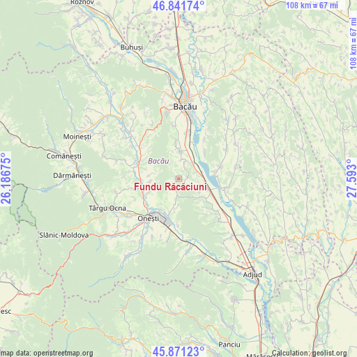
Fundu Răcăciuni GPS coordinates[2]
46° 21' 31.104" North, 26° 53' 23.532" East
| Map corner | latitude | longitude |
|---|---|---|
| Upper-left | 46.84174°, | 26.18675° |
| Center: | 46.35864°, | 26.88987° |
| Lower-right: | 45.87123°, | 27.593° |
| Map W x H: | 107.9×107.9 km | = 67×67mi |
| max Lat: | 48.23793° ⇑36.4% North |
| Fundu Răcăciuni: | 46.35864° |
| min Lat: | ⇓63.6% South 43.65638° |
| min Long | Fundu Răcăciu | max Long |
| 20.31667° | 26.88987° | 29.65403° |
| W 80.8%⇐ | ⇒19.2% E |
Elevation
Elevation of Fundu Răcăciuni is 264 m = 866 ft, and this is 9.1 m = 30 ft above average elevation for this country.
| Max E: |
1278 m = 4193 ft | 39.8% |
| Fundu Răcăciuni | 264 m 866 ft | |
| Avg. | 254.9 m = 836 ft | |
Min E: |
-2 m = -7 ft | 60.2% |
See also: Romania elevation on elevation.city.
Geographical zone
Fundu Răcăciuni is located in North temperate zone (between Tropic of Cancer and the Arctic Circle). Distance of this North polar circle is 2246.6 km =1396 mi to North.| Distance of | km | miles | from Fundu Răcăciuni |
|---|---|---|---|
| North Pole | 4852.5 | 3015.2 | to North |
| Arctic Circle | 2246.6 | 1396 | to North |
| Tropic Cancer | 2548.7 | 1583.7 | to South |
| Equator | 5154.6 | 3202.9 | to South |


Nearby cities:
15 places around Fundu Răcăciuni: (largest is in red/bold)
• Brătila
9.7 km =6 mi,  246°
246°
• Ciucani
3.5 km =2.2 mi,  75°
75°
• Cleja
6.5 km =4 mi,  6°
6°
• Deleni
8.7 km =5.4 mi,  266°
266°
• Drăgugești
8.9 km =5.5 mi,  276°
276°
• Drăgușani
10 km =6.2 mi,  132°
132°
• Dumbrava
5.4 km =3.4 mi,  179°
179°
• Faraoaní
8.3 km =5.2 mi, 5°
• Gheorghe Doja
6 km =3.7 mi,  68°
68°
• Păltinata
8.3 km =5.2 mi, 182°
• Răcăciuni
7.7 km =4.8 mi,  111°
111°
• Rădoaia
6.2 km =3.9 mi,  151°
151°
• Somușca
5.1 km =3.2 mi,  19°
19°
• Temelia
7.7 km =4.8 mi,  188°
188°
• Valea Mică
5.6 km =3.5 mi,  49°
49°
Sources, notices
• [Note1] Compared only with cities in Romania existing in our database
• [Src1] Map data: © OpenStreetMap contributors (CC-BY-SA)
• [Src2] Other city data from geonames.org with taken over terms of usage.
• [Src3] Geographical zone / Annual Mean Temperature by Robert A. Rohde @ Wikipedia
