Fruntișeni geodata
Fruntișeni (Vaslui) is a seat of a second-order administrative division; located in Romania in Europe/Bucharest (GMT+3) time zone. With population of 918 people, there are 4550 cities with bigger population in this country. Compared to other cities in Romania, 59.8% of cities are located further ↓South; 94% of cities are located further ←West and 67.7% of cities have higher elevation than Fruntișeni. Note1


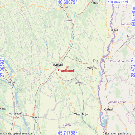
Fruntișeni GPS coordinates[2]
46° 12' 22.824" North, 27° 46' 8.544" East
| Map corner | latitude | longitude |
|---|---|---|
| Upper-left | 46.69079°, | 27.06592° |
| Center: | 46.20634°, | 27.76904° |
| Lower-right: | 45.71758°, | 28.47217° |
| Map W x H: | 108.2×108.2 km | = 67.2×67.2mi |
| max Lat: | 48.23793° ⇑40.2% North |
| Fruntișeni: | 46.20634° |
| min Lat: | ⇓59.8% South 43.65638° |
| min Long | Fruntișeni | max Long |
| 20.31667° | 27.76904° | 29.65403° |
| W 94%⇐ | ⇒6% E |
Elevation
Elevation of Fruntișeni is 136 m = 446 ft, and this is 118.9 m = 390 ft below average elevation for this country.
| Max E: |
1278 m = 4193 ft | 67.7% |
| Avg. | 254.9 m = 836 ft | |
| Fruntișeni | 136 m = 446 ft | |
Min E: |
-2 m = -7 ft | 32.3% |
See also: Romania elevation on elevation.city.
Geographical zone
Fruntișeni is located in North temperate zone (between Tropic of Cancer and the Arctic Circle). Distance of this North polar circle is 2263.5 km =1406.5 mi to North.| Distance of | km | miles | from Fruntișeni |
|---|---|---|---|
| North Pole | 4869.4 | 3025.7 | to North |
| Arctic Circle | 2263.5 | 1406.5 | to North |
| Tropic Cancer | 2531.7 | 1573.1 | to South |
| Equator | 5137.7 | 3192.4 | to South |


Nearby cities:
15 places around Fruntișeni: (largest is in red/bold)
• Banca
10.7 km =6.6 mi,  12°
12°
• Brădești
4.9 km =3 mi,  176°
176°
• Bursuci
7.5 km =4.7 mi,  76°
76°
• Bârlad
8.2 km =5.1 mi,  290°
290°
• Docani
7.4 km =4.6 mi,  190°
190°
• Grăjdeni
2 km =1.2 mi,  158°
158°
• Lupești
9.2 km =5.7 mi,  109°
109°
• Obârșeni
5.6 km =3.5 mi,  117°
117°
• Odaia Bursucani
7.5 km =4.7 mi,  216°
216°
• Pleșa
10.3 km =6.4 mi,  133°
133°
• Popeni
5.3 km =3.3 mi,  31°
31°
• Simila
8.2 km =5.1 mi,  320°
320°
• Trestiana
9.2 km =5.7 mi,  265°
265°
• Vinderei
6.7 km =4.2 mi, 159°
• Zorleni
7.8 km =4.8 mi,  329°
329°
Sources, notices
• [Note1] Compared only with cities in Romania existing in our database
• [Src1] Map data: © OpenStreetMap contributors (CC-BY-SA)
• [Src2] Other city data from geonames.org with taken over terms of usage.
• [Src3] Geographical zone / Annual Mean Temperature by Robert A. Rohde @ Wikipedia
