Zorleni geodata
Zorleni (Vaslui) is a seat of a second-order administrative division; located in Romania in Europe/Bucharest (GMT+3) time zone. With population of 9,511 people, there are 236 cities with bigger population in this country. Compared to other cities in Romania, 61.1% of cities are located further ↓South; 93.4% of cities are located further ←West and 87.4% of cities have higher elevation than Zorleni. Note1


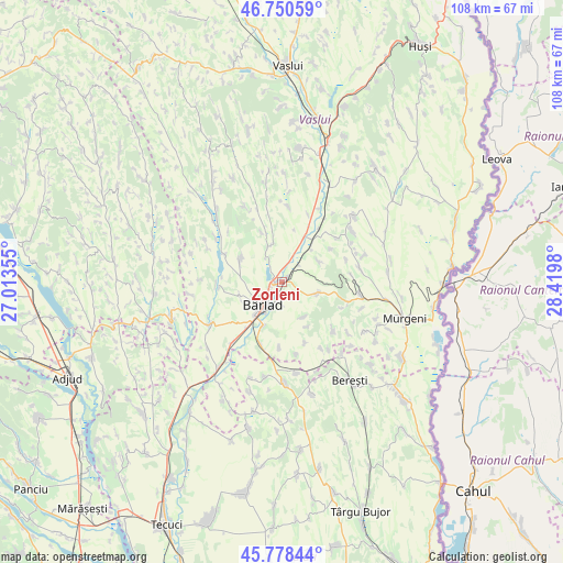
Zorleni GPS coordinates[2]
46° 16' 0.012" North, 27° 43' 0.012" East
| Map corner | latitude | longitude |
|---|---|---|
| Upper-left | 46.75059°, | 27.01355° |
| Center: | 46.26667°, | 27.71667° |
| Lower-right: | 45.77844°, | 28.4198° |
| Map W x H: | 108.1×108.1 km | = 67.2×67.2mi |
| max Lat: | 48.23793° ⇑38.9% North |
| Zorleni: | 46.26667° |
| min Lat: | ⇓61.1% South 43.65638° |
| min Long | Zorleni | max Long |
| 20.31667° | 27.71667° | 29.65403° |
| W 93.4%⇐ | ⇒6.6% E |
Elevation
Elevation of Zorleni is 70 m = 230 ft, and this is 184.9 m = 607 ft below average elevation for this country.
| Max E: |
1278 m = 4193 ft | 87.4% |
| Avg. | 254.9 m = 836 ft | |
| Zorleni | 70 m = 230 ft | |
Min E: |
-2 m = -7 ft | 12.6% |
See also: Romania elevation on elevation.city.
Geographical zone
Zorleni is located in North temperate zone (between Tropic of Cancer and the Arctic Circle). Distance of this North polar circle is 2256.8 km =1402.3 mi to North.| Distance of | km | miles | from Zorleni |
|---|---|---|---|
| North Pole | 4862.7 | 3021.5 | to North |
| Arctic Circle | 2256.8 | 1402.3 | to North |
| Tropic Cancer | 2538.5 | 1577.4 | to South |
| Equator | 5144.4 | 3196.6 | to South |


Nearby cities:
15 places around Zorleni: (largest is in red/bold)
• Banca
7.4 km =4.6 mi,  59°
59°
• Brădești
12.4 km =7.7 mi,  159°
159°
• Bursuci
12.3 km =7.6 mi,  113°
113°
• Bârlad
5.3 km =3.3 mi,  223°
223°
• Băcani
8.3 km =5.2 mi,  332°
332°
• Ciocani
12.1 km =7.5 mi,  266°
266°
• Fruntișeni
7.8 km =4.8 mi,  149°
149°
• Gara Banca
10 km =6.2 mi,  36°
36°
• Ghermănești
11.4 km =7.1 mi, 55°
• Grăjdeni
9.8 km =6.1 mi, 150°
• Odaia Bursucani
12.7 km =7.9 mi,  182°
182°
• Perieni
8.5 km =5.3 mi,  295°
295°
• Popeni
7.2 km =4.5 mi, 108°
• Simila
1.2 km =0.7 mi,  252°
252°
• Trestiana
9 km =5.6 mi,  214°
214°
Sources, notices
• [Note1] Compared only with cities in Romania existing in our database
• [Src1] Map data: © OpenStreetMap contributors (CC-BY-SA)
• [Src2] Other city data from geonames.org with taken over terms of usage.
• [Src3] Geographical zone / Annual Mean Temperature by Robert A. Rohde @ Wikipedia
