Bârlad geodata
Bârlad (Vaslui) is a seat of a second-order administrative division; located in Romania in Europe/Bucharest (GMT+3) time zone. With population of 67,818 people, there are 41 cities with bigger population in this country. Compared to other cities in Romania, 60.3% of cities are located further ↓South; 92.9% of cities are located further ←West and 87.4% of cities have higher elevation than Bârlad. Note1


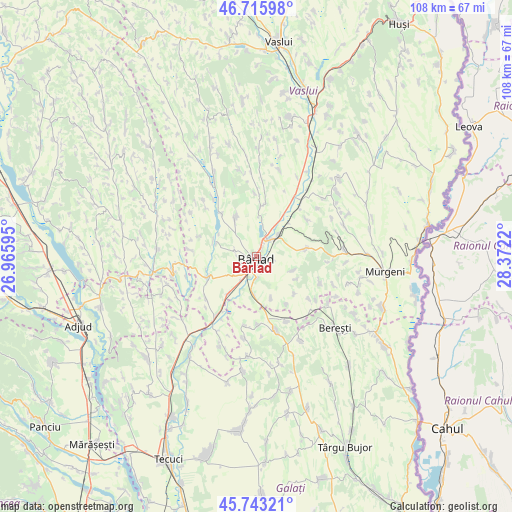
Bârlad GPS coordinates[2]
46° 13' 54.3" North, 27° 40' 8.652" East
| Map corner | latitude | longitude |
|---|---|---|
| Upper-left | 46.71598°, | 26.96595° |
| Center: | 46.23175°, | 27.66907° |
| Lower-right: | 45.74321°, | 28.3722° |
| Map W x H: | 108.2×108.2 km | = 67.2×67.2mi |
| max Lat: | 48.23793° ⇑39.7% North |
| Bârlad: | 46.23175° |
| min Lat: | ⇓60.3% South 43.65638° |
| min Long | Bârlad | max Long |
| 20.31667° | 27.66907° | 29.65403° |
| W 92.9%⇐ | ⇒7.1% E |
Elevation
Elevation of Bârlad is 70 m = 230 ft, and this is 184.9 m = 607 ft below average elevation for this country.
| Max E: |
1278 m = 4193 ft | 87.4% |
| Avg. | 254.9 m = 836 ft | |
| Bârlad | 70 m = 230 ft | |
Min E: |
-2 m = -7 ft | 12.6% |
See also: Bârlad elevation on elevation.city.
Geographical zone
Bârlad is located in North temperate zone (between Tropic of Cancer and the Arctic Circle). Distance of this North polar circle is 2260.7 km =1404.7 mi to North.| Distance of | km | miles | from Bârlad |
|---|---|---|---|
| North Pole | 4866.6 | 3024 | to North |
| Arctic Circle | 2260.7 | 1404.7 | to North |
| Tropic Cancer | 2534.6 | 1574.9 | to South |
| Equator | 5140.5 | 3194.2 | to South |


Nearby cities:
15 places around Bârlad: (largest is in red/bold)
• Brădești
11.2 km =7 mi,  134°
134°
• Băcani
11.3 km =7 mi,  359°
359°
• Bădeana
11.2 km =7 mi,  215°
215°
• Ciocani
9 km =5.6 mi,  290°
290°
• Docani
11.9 km =7.4 mi,  147°
147°
• Fruntișeni
8.2 km =5.1 mi,  110°
110°
• Griviţa
9.2 km =5.7 mi,  189°
189°
• Grăjdeni
9.6 km =6 mi,  119°
119°
• Iveşti
11.8 km =7.3 mi,  242°
242°
• Odaia Bursucani
9.4 km =5.8 mi,  159°
159°
• Perieni
8.6 km =5.3 mi,  332°
332°
• Popeni
10.6 km =6.6 mi,  80°
80°
• Simila
4.3 km =2.7 mi,  35°
35°
• Trestiana
3.8 km =2.4 mi,  202°
202°
• Zorleni
5.3 km =3.3 mi, 43°
Sources, notices
• [Note1] Compared only with cities in Romania existing in our database
• [Src1] Map data: © OpenStreetMap contributors (CC-BY-SA)
• [Src2] Other city data from geonames.org with taken over terms of usage.
• [Src3] Geographical zone / Annual Mean Temperature by Robert A. Rohde @ Wikipedia
